Home - Discipline - River and Reservoir System Modelling
River and Reservoir System Modelling

River and Reservoir Systems Modelling

The group broadly undertakes studies in meteorology, applied hydrology, physico-chemical methods for water quality and hydraulics of surficial processes. This laboratory consists of three technical divisions viz., Hydrometeorology, Water Quality Analysis and Modelling and Surface Water Hydraulics. The group thus conducts studies in river and reservoir systems by field experimentations, mathematical modelling tools and site specific desk studies.

I. HYDROMETEOROLOGY DIVISION

Hydrometeorology division was formed in 2012 by merging the erstwhile Physics (formed in 1947) and Statistics (formed in 1947) divisions to cater to the needs of the clients requiring specific studies to be carried out in applied hydrology, meteorology applied in hydrology and statistics. In the initial phase of its functioning, the Physics division had contributed to water resources sector through electrical analogy approach in offering solutions for PMF estimation, seepage, subsurface flows and flood routing. With the application of computers in hydrology and other fields, Physics division also inherited the mathematical modelling technique and adopted many a models and also developed some in the area of work. On the other hand, the statistics division was conceived to cater to hydrology as well as hydraulic modelling groups in data analysis of various projects adopting stochastic, probabilistic approaches and optimization techniques.

  • Estimation of PMF/SPF for water resources projects and flood forecasting
    • Narmada, Tapi, Mahanadi, Koldam
  • Area Drainage and Determination of Safe Grade Elevation Studies
    • Durgapur, Raghunathpur, Solapur, Hazira
  • Soil erosion and sediment yield for catchments and mine areas
    • Indravati, Kudremukh, Visakhapatnam
  • Water Resources Planning and Management
    • Krishna-Koyana, DSS(P)
  • Statistic and Probabilistic Modelling of hydrometeorological data
    • Stochastic methods (Time Series, Dependability, IDF)
    • Probabilistic methods (Extreme Value Analysis, Low Flow Analysis)
      • NPPs of NPCIL, Pamba-Periyar, Nagothane (RIL)
    • Optimisation Techniques (Chambal, Upper Bhima)
  • Water availability studies
    • Wellington, Lara, Goa(Mandovi)
  • Backwater studies for lift irrigation and power generation projects
    • Pranhita (Irrigation), Neilla Dam (Power)
  • Adoption of Hydrologic Models for River Basins
    • Rainfall-Runoff (Sarda-Varaha, Markandeya)
    • PMF/ SPF for water resources projects
    • Sediment Yield (Kondagedda at Visakhapatnam)
    • Evaporation Estimation (Malshej, Khandala)
  • Development of Models
    • Rainfall-Runoff (Narmada, Tapi)
    • Flood Forecasting Models (Godavari, Mahanadi, Koldam)
    • Irrigation Return Flows (HP I)
    • Water Balance Studies (Malshejghat PSS, Khandala Watershed)
  • Software and Models Used
    • OPSET, TANK, WYM, USLE, KINEROS, HEC-RAS, HEC1, HEC6, MIKE-BASIN
    • Idrisi, SPSS, VTFIT, Hydogenom, HFA, HYMOS, SWDES, AutoCAD

Extreme Value Analysis (EVA) of Meteorological Parameters

EVA of meteorological parameters (rainfall, temperature, wind speed, evaporation, etc.) forms a part of the technical and engineering investigations for designing Nuclear Power Plants (NPPs), which need to be safeguarded against natural hazards. Nuclear Power Corporation of India Limited (NPCIL) proposes to setup NPPs at Banswara (Rajasthan), Bhimpur (Madhya Pradesh), Chutka (Madhya Pradesh), Kovvada (Andhra Pradesh), Mithi Virdi (Gujarat) and Gorakhpur (Haryana), CWPRS carried out EVA of meteorological parameters recorded at the meteorological stations, which are in the vicinity of the NPPs and the results obtained from the studies would be useful to NPCIL for arriving at design parameters for the proposed NPPs.

Estimation of Probable Maximum Flood

The estimation of PMF for Narmada at various locations i.e., Narmada Sagar, Maheshwar, Omkareshwar and Sardar Sarovar was carried out by this division under World Bank aide. The studies were carried out adopting lumped conceptual model OPSET (modified version of Stanford Watershed Model). Flood moderation in river channel was modelled adopting Muskingum method. The model was developed for the whole of Narmada catchment from its source to Sardar Sarovar. Evaluation of the model studies conducted was made by World Bank experts and PMF estimated by CWPRS was adopted for design.

Flood Frequency Analysis

Estimation of maximum flood discharge (MFD) with a specified return period is crucial for the design of hydraulic structures. MFD can be effectively determined by fitting of probability distributions to the series of recorded annual maximum discharge (AMD) data. An AMD is the highest instantaneous discharge value at a definite cross-section of a natural stream throughout an entire hydrologic year (water year). CWPRS carried out flood estimation studies for rivers Krishna, Narmada, Godavari, Tapi, etc.

The FFA technique was also adopted by CWPRS to estimate the extreme max/ min values of other meteorological parameters such as Rainfall, windspeed, temperatures, etc. Some of the projects are NPPs of NPCIL wherein the design parameters were derived and river valley projects wherein the rainfall was used to compute design flood.

Low-Flow Frequency Analysis

Evaluation of low-flow characteristics of a river is fundamental to the assessment of water resources for many direct and indirect uses such as municipal, irrigation, hydropower, public water supply, etc. which is also carried out by flood frequency analysis approach involving fitting of distribution to the series of annual minimum average flows derived from the recorded discharge data. CWPRS carried out the low-flow studies for Narmada, Godavari, Pamba and Periyar river basins. Results obtained from the study were taken as indicators by the stakeholders for making decisions on varied water resources management issues in the reaches of river basins. It is thus a tool in planning long term water resources.

Intensity-Duration-Frequency Analysis

Rainfall intensities of various frequencies and durations are the important parameter for the design of hydraulic structures, as also for rainfall-runoff models. The intensity-duration-frequency (IDF) relationship can be developed through rainfall frequency analysis (RFA) that is used to estimate rainfall depth at a point for a specified exceedance probability and duration. RFA for a site is generally based on point analyses. CWPRS developed IDF curves for a number of projects which include, Kanyakumari, Kalingapatnam, Hissar, Jabalpur, Mandla, Shivpuri and Visakhapatnam regions. The IDF relationships were developed using rainfall estimates obtained from probability distributions. These are useful for decision makers to estimate the rainfall intensity for any specific return period in a short time and hence are useful in planning and designing of any water resources projects.

Determination Safe Grade Elevation and Area Drainage Studies

Safe Grade Elevation (SGE) for a project area is the elevation, which is above the possible inundation level of the area. SGE is determined based on the area drainage studies of the region of proposed project area (Maximum Flood Levels) and project layout plan. During the study on SGE are safety of the project and cost (initial and recurring) are considered for optimization. The finalisation of SGE also takes into account the storm water drainage network for project for safe evacuation of flood water from plant area. <o:p>&nbsp; Solapur, Kudagi of NTPC; Hazira and Kehalgaon of RIL , Durgapur, Raghunathpur of WAPCOS and other organizations such as TPCL, TPCIL, REL, etc are a few typical projects to mention

Estimation of Irrigation Return Flows

A mathematical model has developed for estimation of Irrigation Return Flow (IRF) from command area. The study was carried out as a collaborative research between CWPRS and DIRD, GoM under hydrology project (HP-I). A process based and semi-distributed model “RETRNFLO” was developed for an area of 1339 ha in Kukudi Left Bank Canal Command near village Nighoj, Ahmednagar. The IRF estimated by model from commanad area over 11 nos. Irrigation rotation basis for rabi and kharif. IRF model results were in the order of 12-14% of irrigation water supply. The study is useful in improving the irrigation efficiencies and planning better water distribution. The model was appreciated by World Bank experts and Mantralaya, Mumbai.

Backwater studies – Pranahita Chevella Project

Afflux developed by presence of any structure (weir, barrage, and dam) in a water course is widely known as backwater effect and has both useful (storage) and harmful impacts (flooding).

Backwater has long been vital concern to man and thus a subject to understand, construct and improve the transport of water via waterways such as canals, river, and reservoirs. CWPRS carried out the backwater studies for Pranahita-Chevella Project for state Government of Telangana. Based on the requirement of the project, 1-D hydraulic flood routing model HEC-RAS under steady state conditions was adopted to study the backwater effect of barrage for different flood events i.e. (i) observed flood, (ii) conservative flood and (iii) combined flood discharges and barrage levels. As required by the project authorities, an assessment of lowering of barrage height on the flood levels and resulting change in storage capacity of project was studied.

Soil erosion-sediment yield studies – Visakhapatnam

Soil erosion and sediment yield from catchments is an important aspect in water resources as it affects the storage (reservoir), water quality, and rise in bed levels of river sections leading to flooding. CWPRS conducted the studies on Soil erosion and Sediment yield estimation for Kondagedda river near Visakhapatnam. Kondagedda is a un-gauged catchment hence estimation of water and sediment discharges were required for the downstream channelization process along airport. For this, catchment physiographic factors were derived from toposheets and remotely sensed data, etc. Using these, the soil erosion and sediment yield was estimated with USLE, Garde’s method, and Musgrave equation. The sediment yield for Kondagedda watershed upto national highway NH5 crossing was estimated as 82.16 t/ha/yr. In addition the above results were also evaluated with physically based KINEROS2 model, which estimated sediment yield as 89.15 t/ha/yr.

Development of Flood Forecasting Model for Koldam HEP, HP

NTPC Ltd. has proposal to build and operate Koldam upstream of Bhakra dam for hydro-electric power generation. CWPRS developed a flood forecasting model for Satluj river system from Pandoa to Chhaba river gauge to Koldam reservoir. The model was developed with three main components, viz., (i) rainfall-runoff for ungauged catchments adding to Satluj or Koldam reservoir (using Clark’s method), (ii) flood routing for reach Pandoa to Chhaba adopting Muskingum method and (iii) reservoir routing adopting mass balance. The model operates in two modes i.e., (i) test mode; for testing the model with past data and (ii) forecast mode; to issue warnings during forecast operations. Model has provision to provide the decision makers to alter the reservoir levels to control the downstream releases during forecast operations.

Optimization of Hydrometeorological Network for Upper Bhima Basin

Optimization of hydrometeorological network of Upper Bhima basin up to Ujjani reservoir was carried out by CWPRS jointly with Government of Maharashtra; under Hydrology Project (Phase II). This was carried out adopting a spatial hydrologic regression under generalized least squares (GLS) framework to optimize the existing streamgauge and raingauge network of the basin. The study suggested the hydrometric network of 12 GD stations with a network density of 1226 km2 per station and raingauge network consists of 35 rain gauge stations with network density of 450 km2 per station. The optimum network provides support for water resources planning for multi-objectives.

II. WATER QUALITY ANALYSIS AND MODELLING DIVISION

Chemistry Division formed in 1947 has been renamed as Water Quality Analysis and Modelling (WQAM) division in 2012, by expanding the scope of its studies to analyze the water quality of river and reservoir systems by mathematical modelling. The three major activities of WQAM division are (1) Field investigations, sample collection, (2) Laboratory analysis of water, sediment and cement samples and (3) Water Quality Modelling of rivers and reservoirs. <o:p>

Water quality studies are conducted for various rivers and reservoirs for assessing their suitability for various uses e.g. irrigation, hydropower generation, concreting etc. Mathematical model, MIKE21 with HD and WQ modules, are used for estimating carrying capacity of a water body and for futuristic pollution scenarios under different conditions.

Field investigations

Field investigations carried out for rivers and reservoirs like Sardar Sarovar, Panshet, Khadakwasla, Ujjani, Bhadra etc. Apart from water, sediment and biological sample collection, parameters analysed in situ are Secchi depth, Temperature, Conductivity pH.

Laboratory Analysis

Samples analysed for projects include Sardar Sarovar, Panshet, Khadakwasla, Bommanhalli, Ujjani, Tungabhadra and Dandeli Reservoirs; Ennore and Mahim Creek; Trombay; Godavari, Kalinadi, Krishna and Tapi Rivers etc. Some of the instruments used in the laboratory are:

Atomic Absorption Spectrophotometer, Flame Photometer, UV-Visible Spectrophotometer, BOD Incubator, COD Digester, Water Quality Monitor, Compound Microscope, Stereozoom microscope

Water quality modelling

Modelling studies for prediction of futuristic scenario, estimation of pollution-carrying capacity of reservoir/river, identification of best suitable location for point source of pollution, etc are done. The data regarding cross sections/bathymetry of study region, hydrology, hydraulics, meteorological data are required for modelling studies. Water quality data at various locations, if not available, can be collected by CWPRS team. Mathematical studies for Assessment of water quality of Sardar Sarovar reservoir (SSNNL) Gujarat- Part II (Simulation studies)

III. Disaster management planning (DMP) division

Disaster Management Planning (DMP) division has been formed by reorganizing erstwhile Surface Water Hydraulics (SWH) division in year 2019 as per the recommendation of Technical Advisory Committee (TAC) of CWPRS to cater needs of Flood Inundation studies for Emergency Action Planning in case of Dam Break. Dam Safety Bill passed by the Parliament of India in the year 2018 stressed upon the need for preparation of Emergency Action Plan (EAP) for all large dams for Disaster Management Planning. The Bill applies to all dams in the country with: (i) height more than 15 metres, or (ii) height between 10 metres to 15 metres and subject to certain additional design and structural conditions. Central Water Commission (CWC) with financial assistance from World Bank started Dam Rehabilitation and Improvement Project (DRIP) to rehabilitate about 250 large dams in seven states. Formal guidelines are needed to help dam authorities to develop and implement EAP in consultation with local emergency management authorities effectively. Thus knowing the need of the hour, CWPRS established a dedicated division for carrying out disaster management planning studies.

In addition to that, DMP division also undertakes Flood Inundation studies, Storm Water Drainage design and determination of Safe Grade elevation for Power plants & Industrial Establishments, Nala diversion for coal mines and allied sectors and River Morphology studies.

The erstwhile SWH division founded in 1992 initially has contributed in studies for Bank Protection Works, Morphological Studies, River front Development studies including flood zone identification, Reservoir Sedimentation studies, identification of location and design of intake structures for Power Projects, Water Availability studies and so on.

HIGHLIGHTS OF STUDIES CARRIED OUT AT DMP DIVISION

Dam Break studies for Emergency Action Planning and Flood Zone Mapping

Dam break event can have a major impact on the land and communities downstream of the failed structure. It results in large flood waves, may be >10m height travelling at high speeds along the valley downstream of dam, devastating the developed areas. Dam Break studies are carried out with different scenarios of dam breach conditions for estimating the flood inundation levels at the downstream of the dam in case of unfortunate event of Breach of Dams. The estimated flood hydrographs, in the event of breach of Dam are routed dynamically to evaluate the Flood Levels, discharge and velocity for Emergency Action Planning and Disaster Management activities at the downstream of the Dam. Inundation map is an essential input in EAP in case of Dam break, which can be prepared only with Dam Break analysis. Important Dam Break studies carried out so far at CWPRS are for Mallana sagar Dam, Kondapochamma sagar dam under Kaleshwaram project, Kanhar Dam, Tilaya Dam, Ukai Dam, Supa Dam, Bommannnahalli Dam, Kodasalli Dam, Kadra Dam, Gandhisagar Dam, Vishakapatnam Steel Plant etc. Dam break studies for Khadakwasla Dam system, Baswapur Dam and Gandhamala Dam are in progress. A number of dam break analysis studies for other dams in India are under consideration and sanction.

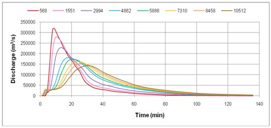
Flood Hydrograph at specified chainages on downstream of dam in event of Dam Break

(For proposed Kanhar Dam Project)

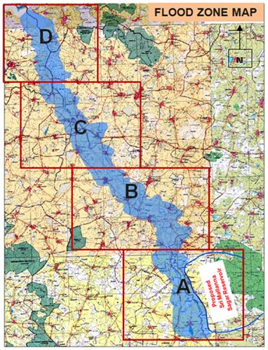
Flood zone inundation map (Dam Break studies of Mallanasagar dam under Kaleshwaram project, Telangana)

B B.Safe Grade Elevation and Area Drainage Studies

The principal contribution of hydrology in disaster management is realization of extreme events and an approach to quantify them. Hydrological investigations and analysis help to mitigate the effects of flood catastrophe by issuing early warnings, by planning for preparedness and by designing various structures. Safe Grade Elevation studies for deciding the founding levels of the significant projects and Area Drainage studies for effective Storm Water Drainage inside project boundary are performed at DMP Division for Storm Water Management. The flood levels i.e. Safe Grade Elevation are determined by routing the flood using one dimensional mathematical model under steady state condition. Area Drainage Studies <i> are carried out for specific project areas for ensuring safe disposal of storm water to nearest outlet (River/stream/ocean) by developing a storm water drainage network for efficient drainage of the project area without hampering the activities due to high floods. Storm Water Drainage network is designed based on design flood, topography and hydraulic conditions of stream system. Some of the important studies carried out for Safe Grade Elevation and Area Drainage studies are Navi Mumbai International Airport (NMIA), Rawatbhata Atomic Power Plant, Kakinada, Kaiga, Kakrapar, Lara, Darlipali, and many other NTPC projects.

New Picture (7)

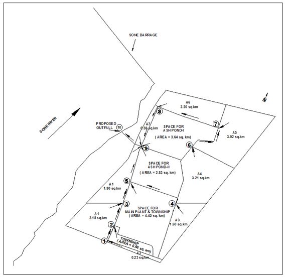
Details of Storm Water Drainage system for Nabinagar Thermal Power Plant

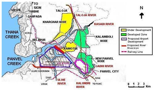
Index map of NMIA Layout-Safe grade elevation study for Navi Mumbai International Airport


C. Nala Diversion Studies

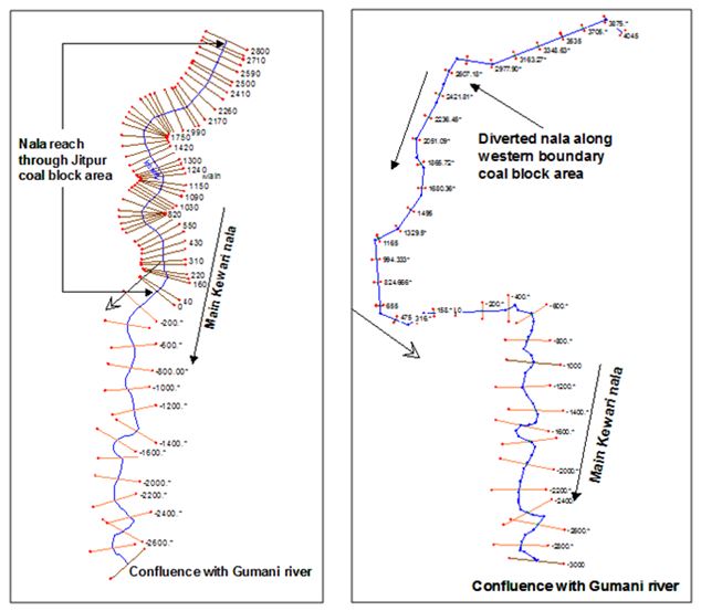
DMP Division carries out studies for Nala/Stream Diversion for the Mining activities and development of infrastructure projects. Many times it becomes necessary to divert natural streams for construction of infrastructure or for extracting valuable resources available beneath them. Keeping the hydrologic regime at the upstream and downstream of the project area undisturbed is a prerequisite for the environmental protection in addition to many other environmental issues. The diversion channels are designed such that the hydrologic regime on upstream and downstream of the project area is undisturbed. Appropriate mathematical modeling studies are used for arriving at the desired hydraulic design. The hydraulic state of the diverted Nala is assessed for a flood of 25, 50 or 100 year return periods as per BIS codes and compared with the pre diversion state to safe guard the hydrologic regime, undisturbed at upstream and downstream areas. DMP division has carried out studies for diversion of Nalas in recent past for Jitpur coal block, Godda, Jharkhand, Chakla coal block, Chandwa, Jharkhand and for Jindal Steel and Power Ltd, Patratu Ranchi, Jharkhand.

Schematic plan for Kewari Nala Diversion (Existing and diverted scenario) in Jitpur district, Godda, Ranchi


D. River Morphology studies

DMP Division undertakes River Morphological studies to understand the Bank line shifting due to changes in flow characteristics. Bank lines of the study reach of the river are extracted from satellite imageries using remote sensing techniques. Erosion/deposition is estimated with reference to bank lines which are demarcated using SOI toposheets. The results are used in the design of bank protection works.

River Morphology Studies have been carried out for Narmada River, Damodar River, Sone River, Ganga River, Gandak River,Gautami Godavari River and so on.

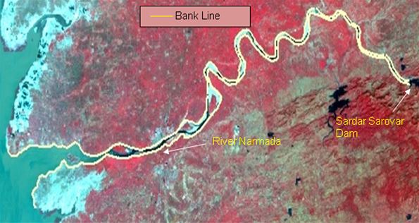
Bank Line of River Narmada downstream of Sardar Sarovar dam demarcated by analyzing satellite imageries

LIST OF CLIENTELE Central /State Government organizations/ Municipal Corp. and PSUs such as WAPCOS, DVC, NTPC, NHPC, NHDC, NPCIL, CIDCO, SMC, BMC, PMC, ONGC and private organizations such as RIL, NECL, TPCIL, REL, JPL, JSPL, USHA MARTIN, Trimula, ESSAR etc.

SOFTWARES AND MODELS USED

HEC RAS, Charima, DAMBRK/FLDWAV, DWOPER/NETWRK, Easi-Pace, ArcGIS and in house developed Rainfall Runoff models and statistical tools .

You are Visitor No.: 3080998
Last Update On: 04/24/2024
Website hosted and maintained by National Informatics Centre Contents provided by CWPRS