JavaScript is disabled in your browser.
Twiter
  • भारत सरकार GOVERNMENT OF INDIA
  • जल शक्ति मंत्रालय Ministry of Jal Shakti
Skip to main content
Search
Search
Search
Accessibility
  • A +
  • A
  • A -
  • A
  • A
Screen Reader
Theme Color
Site Map
 
                  Central Water and Power Research Station
CWPRS
(Since 1916)
logo
Government Of India
Ministry Of Jal Shakti
Department of Water Resources, River Development and Ganga Rejuvenation

Central Water and Power Research Station

Skip to main content
Search
Accessibility
  • A +
  • A
  • A -
  • A
  • A
Screen Reader
Theme Color
Twiter
  • Home
  • About Us
    • About CWPRS
      • General
      • Vision/Mission & Mandate
      • Organogram
      • Former Directors
    • Campus facilities
      • Auditorium
      • Health unit
      • Guest house
      • Colony
      • Canteen
      • Exhibition hall
    • Technical Support Services
      • Administration
      • CPPD
      • TC
      • Raj bhasha
      • Electrical Section
      • Mechanical Workshop
      • LIBIS
      • Pump house
      • E-governance & IT
    • Green Initiatives
      • Solar Rooftop
      • Rainwater Harvesting
      • Composting
    • Awards/Testimonials
    • Who is Who
  • Disciplines
    • River Engineering
      • River Hydraulics (RH)
      • Bridge Engineering (BE)
      • Hydro-meteorology(HMET)
    • River and Reservoir Systems Modelling
      • Hydraulic Analysis and Prototype Testing
      • River Rejuvenation
      • Canal Automation and Measurement
      • Disaster Management Planning
    • Reservoir and Appurtenant Structures
      • Spillways and Energy Dissipators
      • Control Structures and Water Conductor Systems
    • Coastal and Offshore Engineering
      • Ports and Harbours
      • Mathematical Modelling Centre
      • Coastal Hydraulic Structures
      • Coastal Data Centre
    • Foundation & Structures
      • Geotechnical Engineering (Rock Mechanics)
      • Geotechnical Engineering (Soil)
      • Structural Modelling and Analysis
      • Concrete Technology
    • Applied Earth Sciences
      • Engineering Seismology
      • Vibration Technology
      • Geophysics
      • Isotope Hydrology
    • Instrumentation, Calibration & Testing Services
      • Hyd. Instrumentation
      • Dam Instrumentation
      • Hydraulic Machinery, Cavitation & Instrumentation
      • Current Meter Calibration
      • Ingress Protection Testing Laboratory
  • R&D Scheme
    • NHP
      • Meteorological-Sensor
      • Groundwater Levels Sensor
      • Water Quality Sensor
      • Data Logger and Telemetry
      • Current Meter Calibration Laboratory
      • Surface Water Level & Flow Sensors
      • Ingress Protection Testing Laboratory
      • Hydraulic Machinery
    • DRIP
    • CMIS
  • Events
    • Conference
      • Hydro
      • INCHOE 2025
      • Stakeholder Workshop
      • PreciSense 2026
    • Trainings
    • Centenary 2016
  • Citizen Corner
    • Vigilance
    • RTI
      • RTI cell
      • Suo Moto disclosure
      • Progress
      • Reply to RTI
      • Citizen Charter
      • DOCS available in CWPRS Library
    • Public-Grievances
    • ICC
    • IPR Details
  • Vacancies
    • Notification
    • Recruitment Rules
    • Internship
      • Internship Rules
      • Online internship application
  • Publications
    • Annual Report
    • Coffee Table Book
    • Journal Publications
    • Technical Report
    • Technical Memoranda
    • Jal Anusandhan Bulletin
    • CWPRS BROCHURE
    • Compendium
    • Jalavani 2025
  • Tenders
    • Current
    • Archive
  • Employee Corner
    • Notices
    • E-office
    • E-hrms
    • E-granthalya
    • Email
    • SPARROW
  • E-Learning
  • Contact Us
प्रवेश संरक्षण
प्रवेश संरक्षण
  1. Home
  2. Disciplines
  3. Coastal and Offshore Engineering
  4. Coastal Data Centre

Disciplines

River Engineering +
  • River Hydraulics (RH)
  • Bridge Engineering (BE)
  • Hydro-meteorology(HMET)
River and Reservoir Systems Modelling +
  • Hydraulic Analysis and Prototype Testing
  • River Rejuvenation
  • Canal Automation and Measurement
  • Disaster Management Planning
Reservoir and Appurtenant Structures +
  • Spillways and Energy Dissipators
  • Control Structures and Water Conductor Systems
Coastal and Offshore Engineering -
  • Ports and Harbours
  • Mathematical Modelling Centre
  • Coastal Hydraulic Structures
  • Coastal Data Centre
Foundation & Structures +
  • Geotechnical Engineering (Rock Mechanics)
  • Geotechnical Engineering (Soil)
  • Structural Modelling and Analysis
  • Concrete Technology
Applied Earth Sciences +
  • Engineering Seismology
  • Vibration Technology
  • Geophysics
  • Isotope Hydrology
Instrumentation, Calibration & Testing Services +
  • Hyd. Instrumentation
  • Dam Instrumentation
  • Hydraulic Machinery, Cavitation & Instrumentation
  • Current Meter Calibration
  • Ingress Protection Testing Laboratory

Research Highlights

 Research Highlights Image

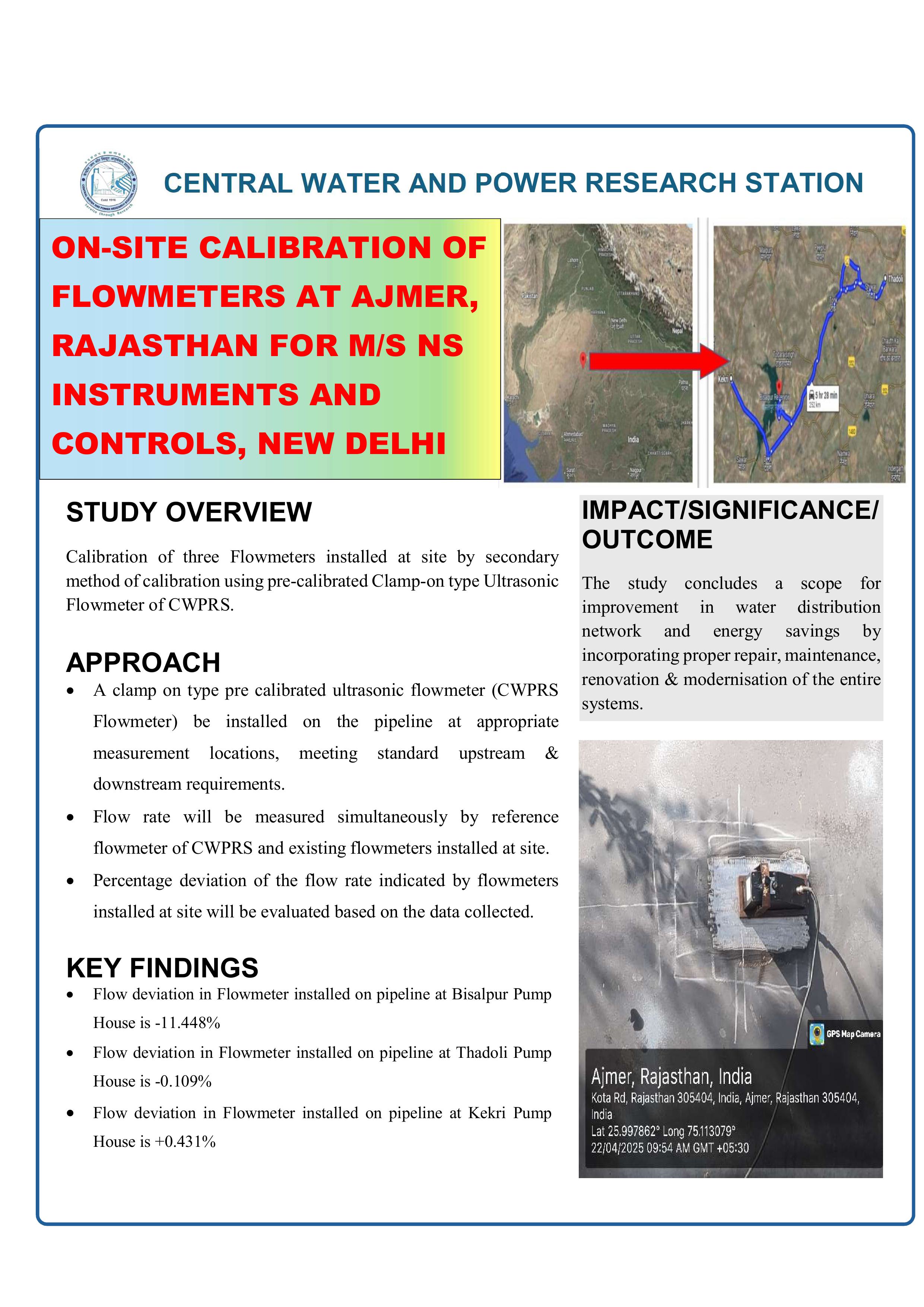
ON-SITE CALIBRATION OF FLOWMETERS AT AJMER, RAJASTHAN FOR M/S NS INSTRUMENTS AND CONTROLS, NEW DELHI

Download
 Research Highlights Image

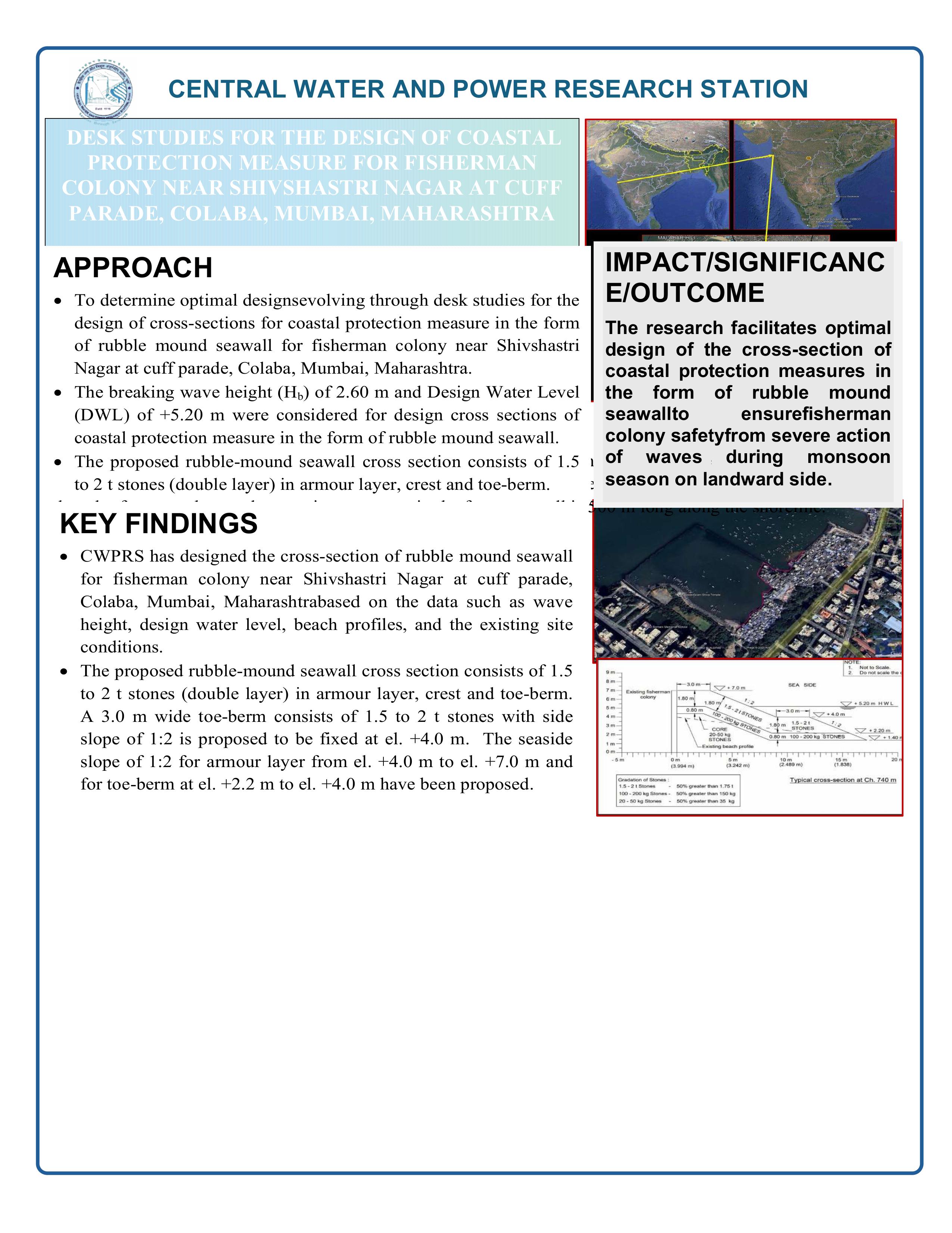
DESK STUDIES FOR THE DESIGN OF COASTAL PROTECTION MEASURE FOR FISHERMAN COLONY NEAR SHIVSHASTRI NAGAR AT CUFF PARADE, COLABA, MUMBAI, MAHARASHTRA

Download
 Research Highlights Image

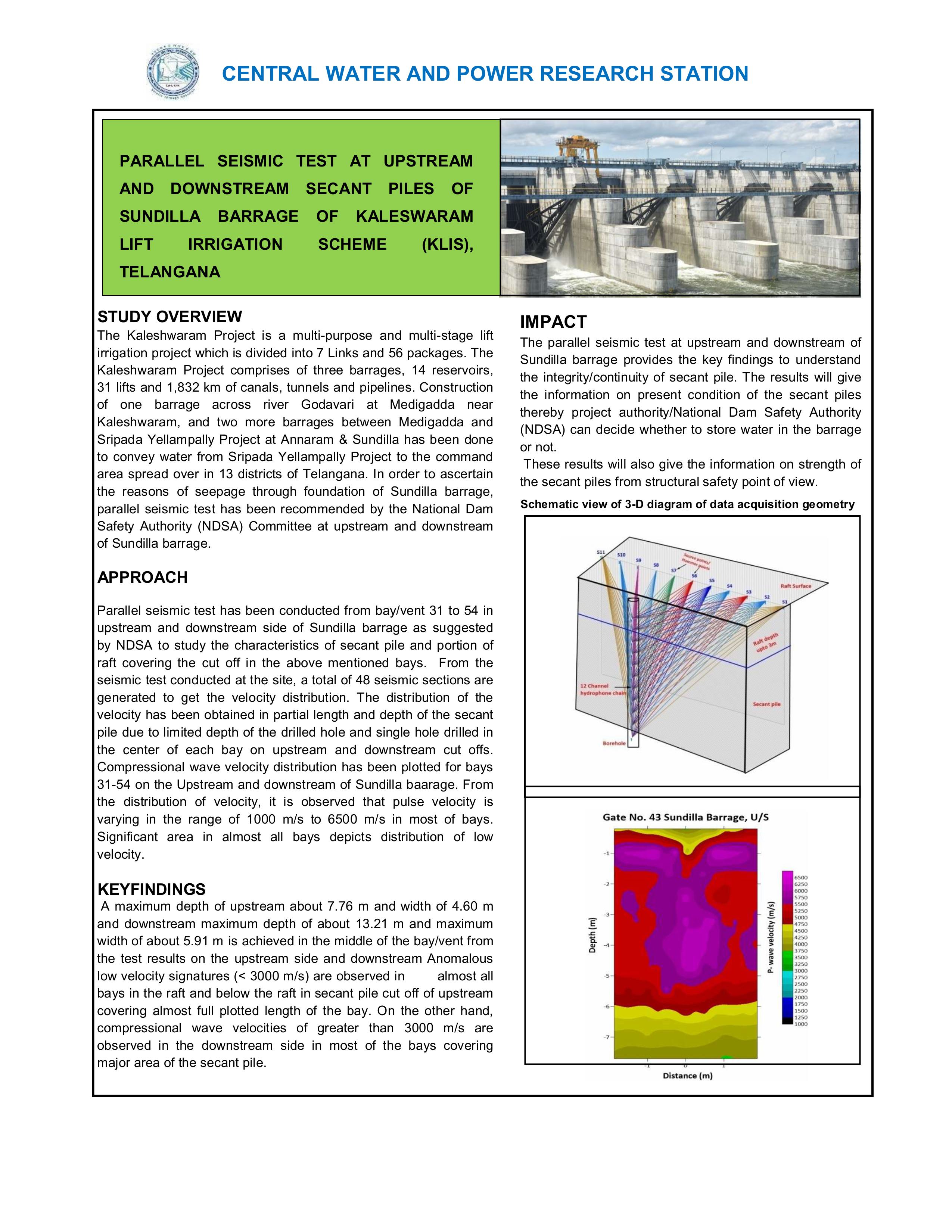
PARALLEL SEISMIC TEST AT UPSTREAM AND DOWNSTREAM SECANT PILES OF SUNDILLA BARRAGE OF KALESWARAM LIFT IRRIGATION SCHEME (KLIS), TELANGANA

Download
 Research Highlights Image

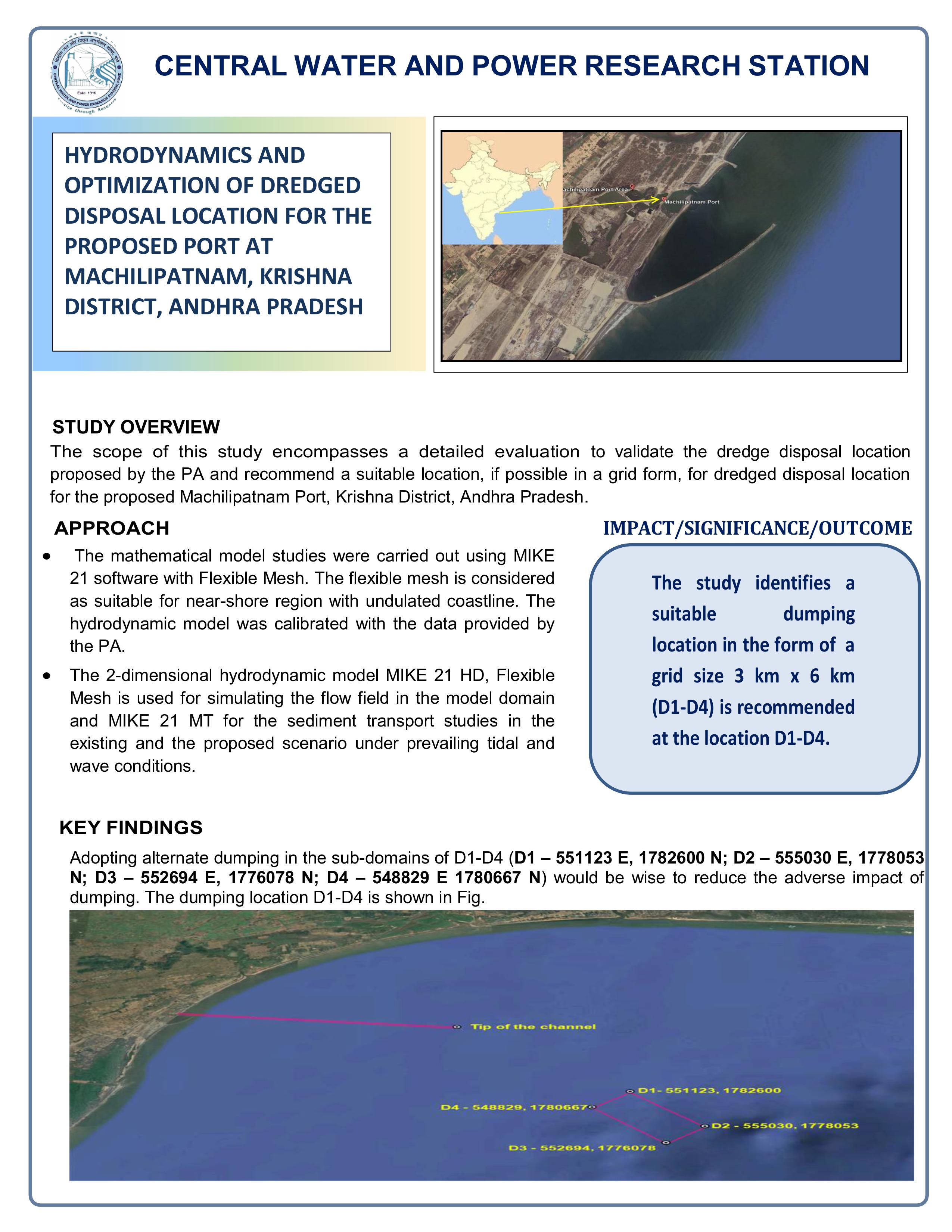
HYDRODYNAMICS AND OPTIMIZATION OF DREDGED DISPOSAL LOCATION FOR THE PROPOSED PORT AT MACHILIPATNAM, KRISHNA DISTRICT, ANDHRA PRADESH

Download
 Research Highlights Image

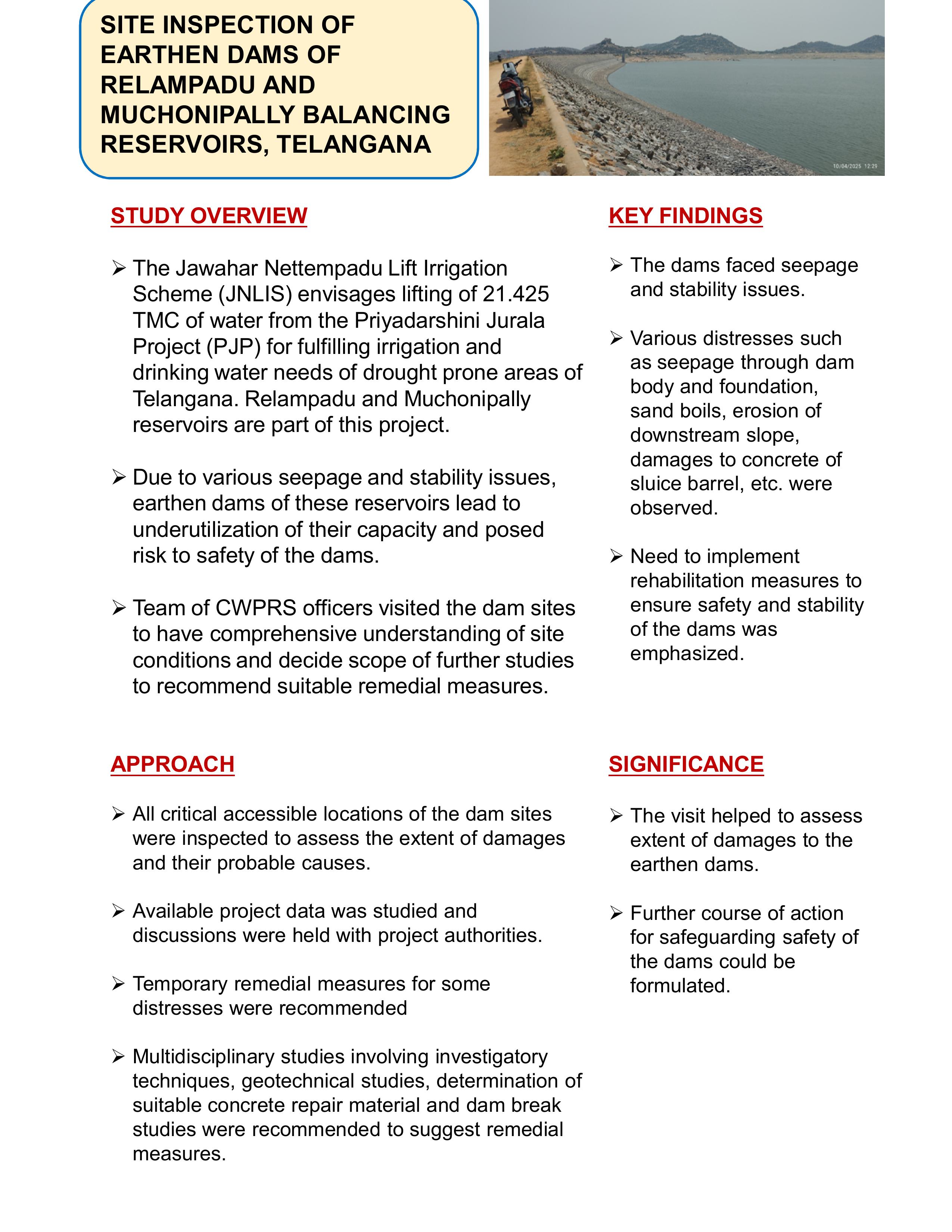
SITE INSPECTION OF EARTHEN DAMS OF RELAMPADU AND MUCHONIPALLY BALANCING RESERVOIRS, TELANGANA

Download
 Research Highlights Image

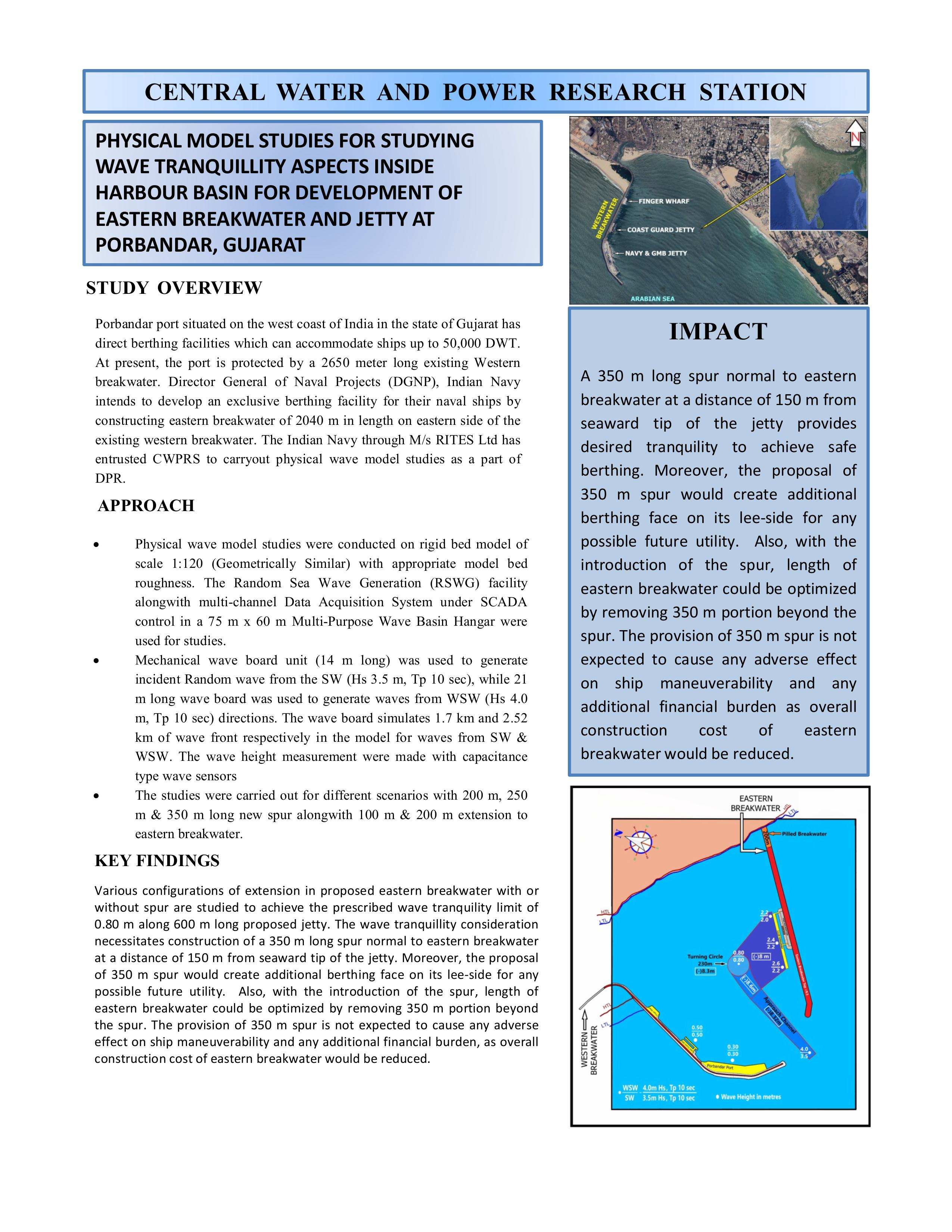
PHYSICAL MODEL STUDIES FOR STUDYING WAVE TRANQUILLITY ASPECTS INSIDE HARBOUR BASIN FOR DEVELOPMENT OF EASTERN BREAKWATER AND JETTY AT PORBANDAR, GUJARAT

Download
 Research Highlights Image

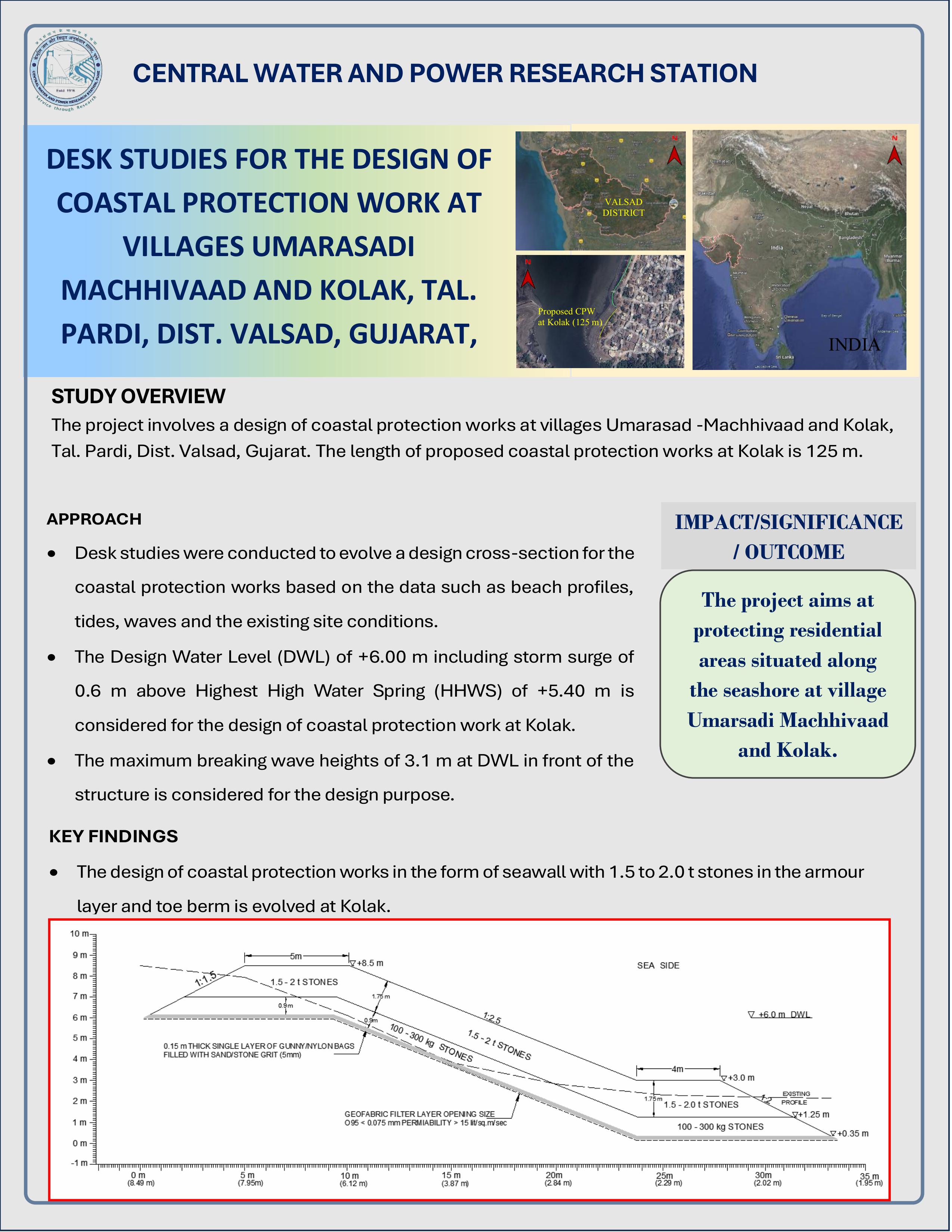
DESK STUDIES FOR DESIGN OF COASTAL PROTECTION WORK AT VILLAGES UMARASADI, MACHHIWAAD, AND KOLAK, TAL. PARDI, DIST. VALSAD, GUJARAT

Download
 Research Highlights Image

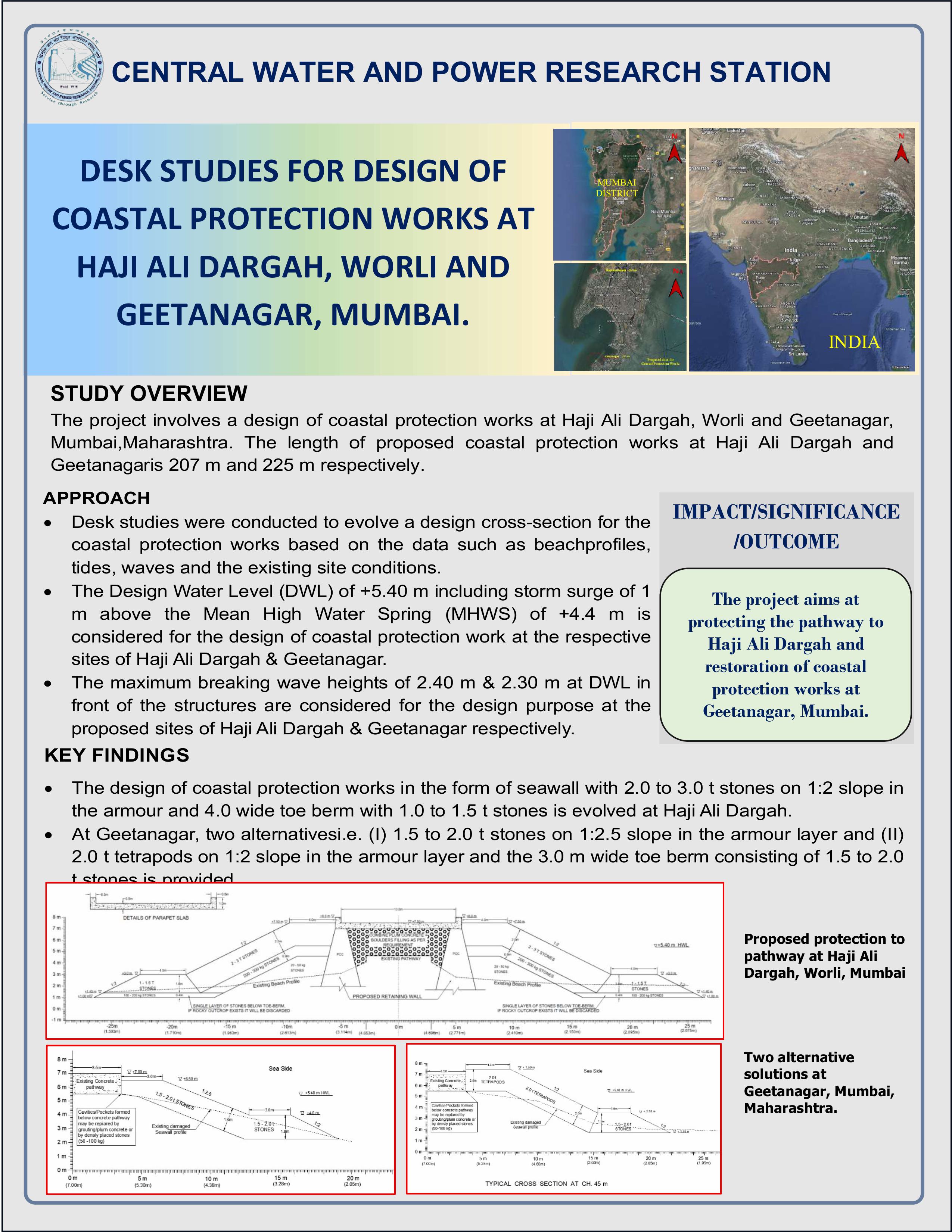
DESK STUDIES FOR DESIGN OF COASTAL PROTECTION WORKS AT HAJI ALI DARGAH, WORLI AND GEETANAGAR, MUMBAI

Download
 Research Highlights Image

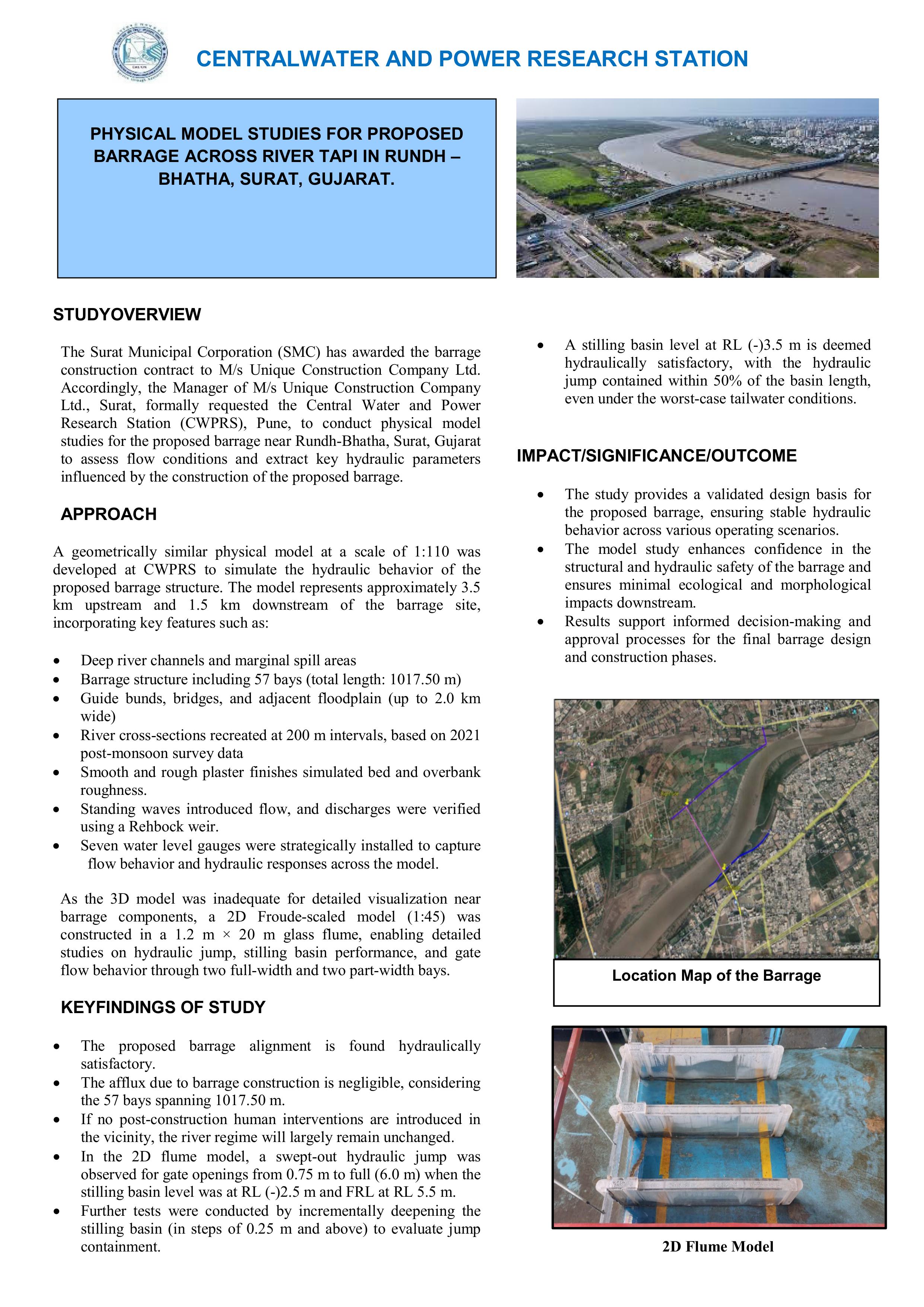
PHYSICAL MODEL STUDIES FOR PROPOSED BARRAGE ACROSS RIVER TAPI IN RUNDH - BHATHA, SURAT, GUJARAT

Download
 Research Highlights Image

SEDMENTATION STUDIES FOR RIVER UMIEW, MEGHALAYA

Download
 Research Highlights Image

The hydrological re-assessment involves evaluating water flow and flood risks for the 198 km new railway line project from Indore to Budhni in Madhya Pradesh, aimed at enhancing rail connectivity under the National Infrastructure Pipeline.

Download
 Research Highlights Image

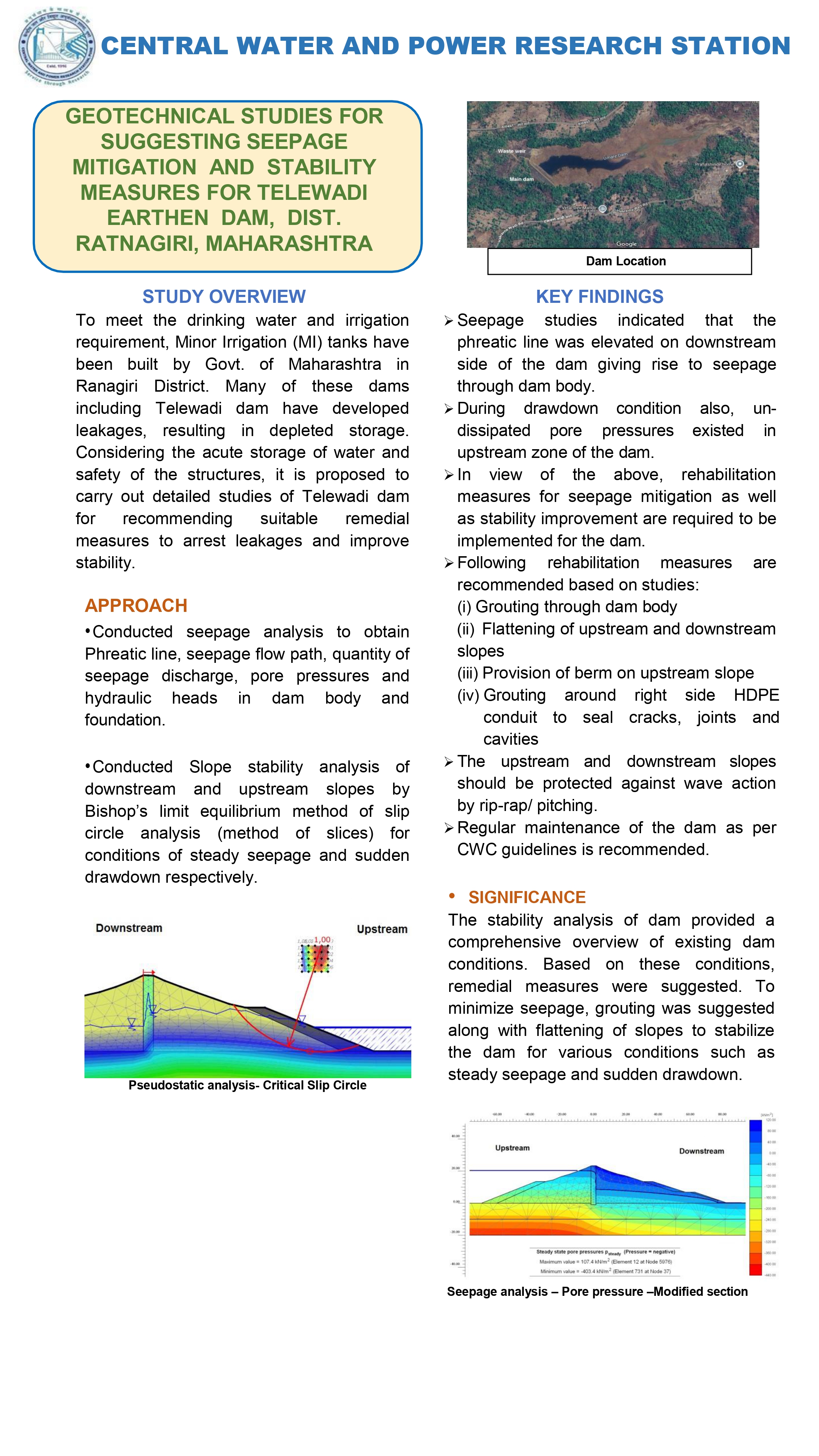
Geotechnical analysis to recommend measures for reducing seepage and enhancing stability of the Telewadi earthen dam, addressing safety concerns through soil and foundation assessments.

Download
 Research Highlights Image

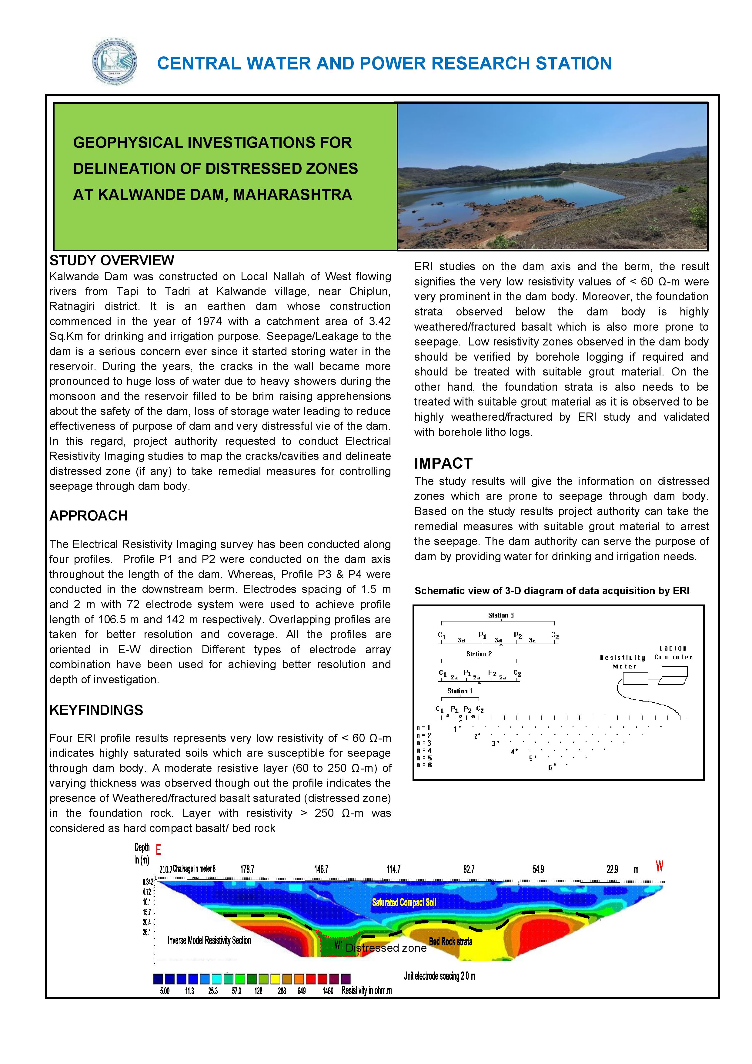
Geophysical surveys using seismic tomography and electrical resistivity to identify and map weak or distressed areas in the Kalwande Dam structure for targeted repairs.

Download
 Research Highlights Image

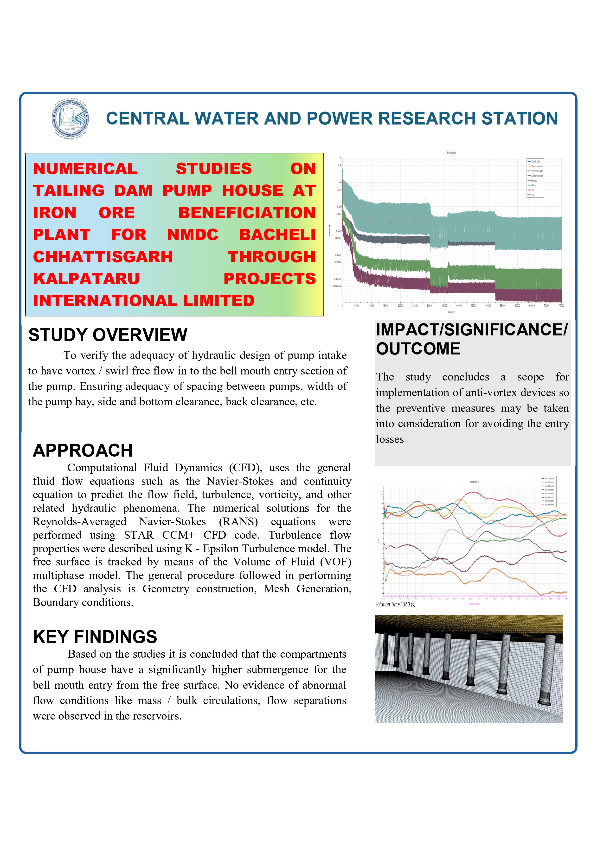
Numerical modeling to assess structural integrity and safety of the pump house at the tailing dam of NMDC's iron ore beneficiation plant in Bacheli, Chhattisgarh.

Download
 Research Highlights Image

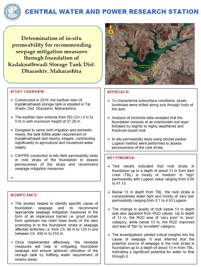
In-situ permeability testing to evaluate foundation seepage risks and propose mitigation strategies for the Kadaknathwadi storage tank in Dharashiv district.

Download
 Research Highlights Image

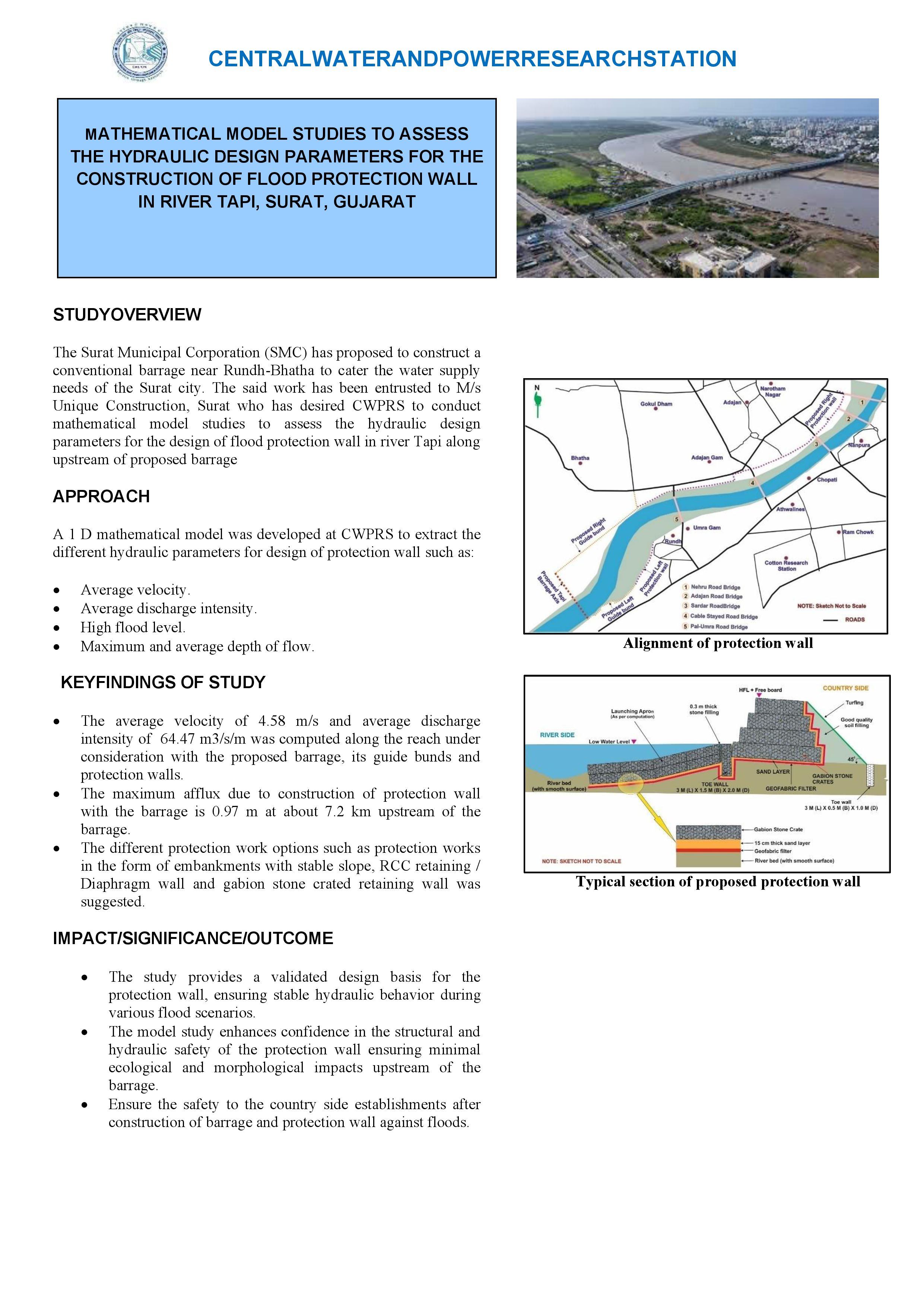
Mathematical modeling using HEC-RAS to determine hydraulic parameters for designing effective flood protection walls along the Tapi River in Surat to mitigate urban flooding.

Download
 Research Highlights Image

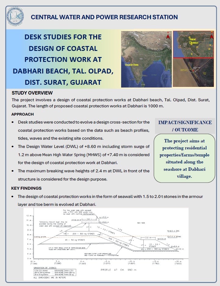
Desk-based analysis for planning coastal protection structures at Dabhari Beach to prevent erosion and support tourism and industrial development in the Olpad taluka area.

Download
 Research Highlights Image

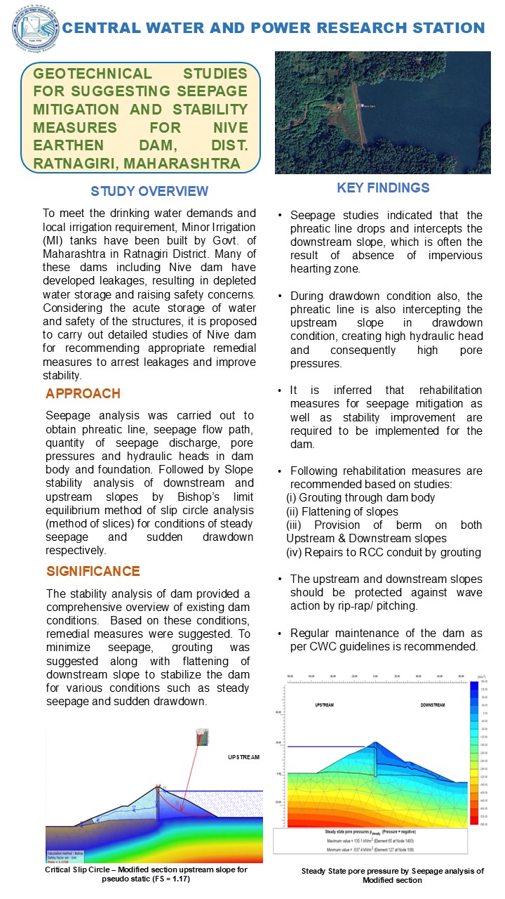
Geotechnical evaluation to propose seepage control and stability enhancements for the Nive earthen dam, ensuring long-term safety through soil mechanics analysis.

Download
 Research Highlights Image

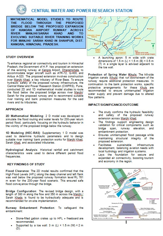
MATHEMATICAL MODEL STUDIES TO ROUTE THE FLOOD THROUGH THE PROPOSED BRIDGE BELOW THE PROPOSED EXPANSION OF KANGRA AIRPORT RUNWAY ACROSS RIVER MANJHI/SARAH KHAD AND TO EVOLVING SUITABLE RIVER TRAINING WORKS FOR MANJHI/ SARAH KHAD IN SHAHPUR, DIST. KANGRA, HIMACHAL PRADESH

Download
 Research Highlights Image

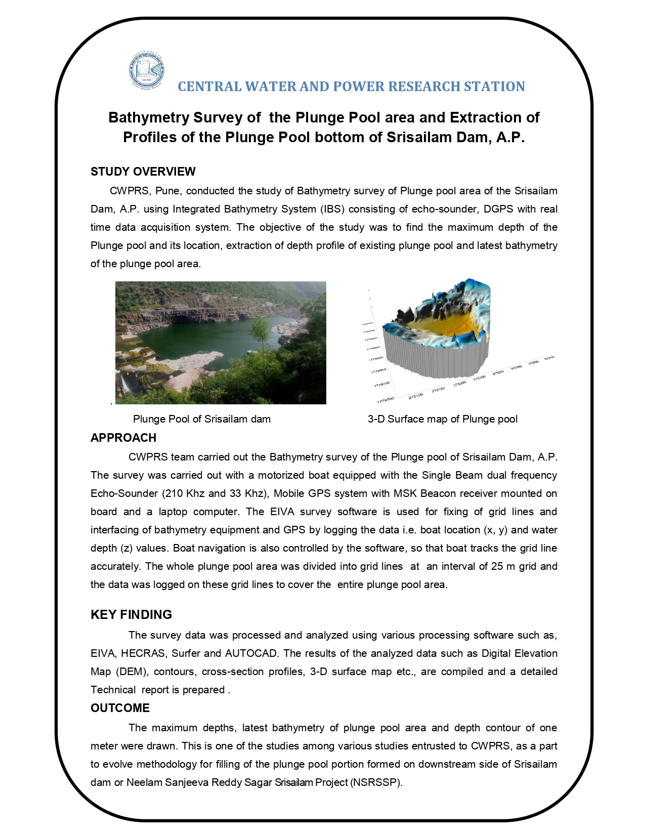
BATHYMETRY SURVEY OF THE PLUNGE POOL AREA AND EXTRACTION OF PROFILES OF THE PLUNGE POOL BOTTOM OF SRISAILAM DAM, A.P.

Download
 Research Highlights Image

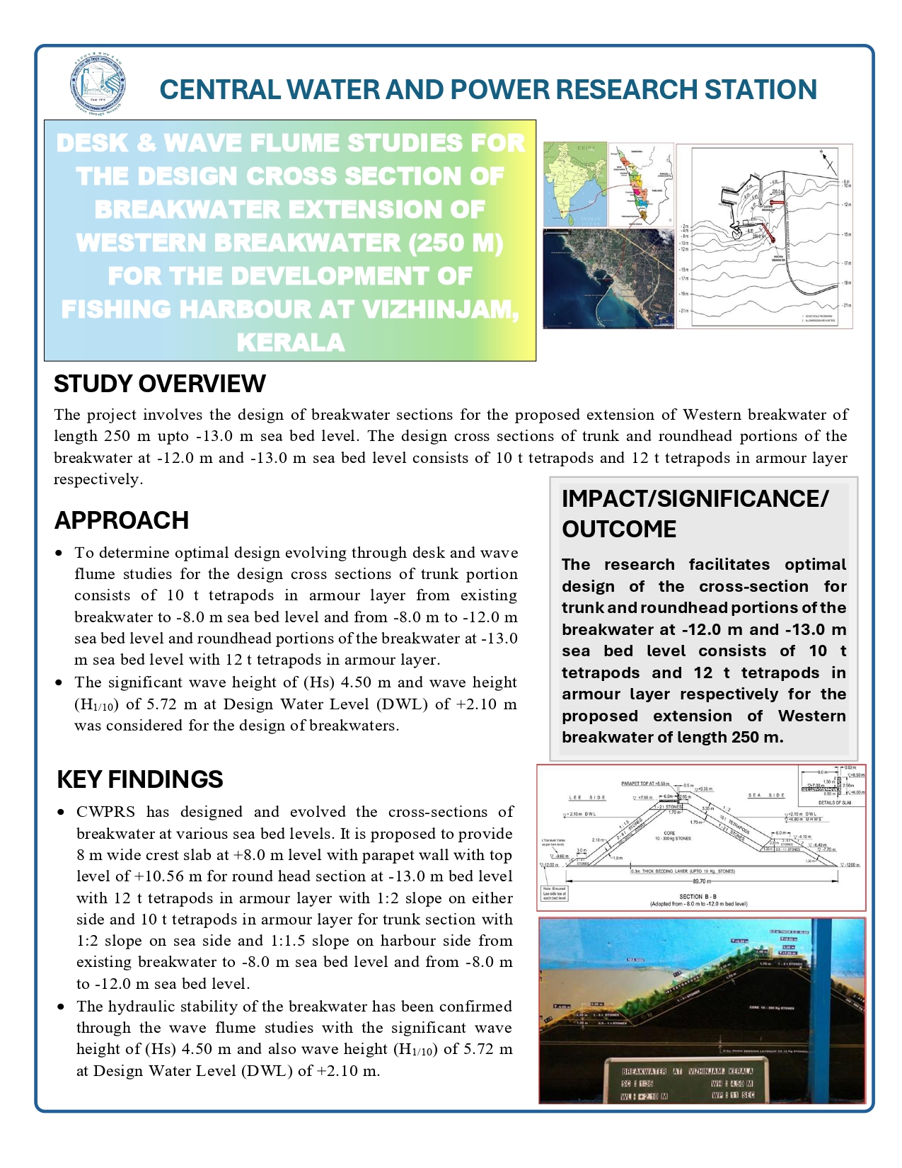
DESK & WAVE FLUME STUDIES FOR THE DESIGN CROSS SECTION OF BREAKWATER EXTENSION OF WESTERN BREAKWATER (250 M) FOR THE DEVELOPMENT OF FISHING HARBOUR AT VIZHINJAM, KERALA

Download
 Research Highlights Image

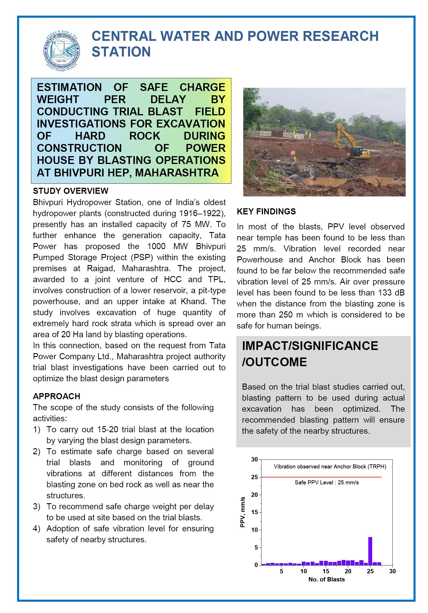
ESTIMATION OF SAFE CHARGE WEIGHT PER DELAY BY CONDUCTING TRIAL BLAST FIELD INVESTIGATIONS FOR EXCAVATION OF HARD ROCK DURING CONSTRUCTION OF POWER HOUSE BY BLASTING OPERATIONS AT BHIVPURI HEP, MAHARASHTRA

Download
 Research Highlights Image

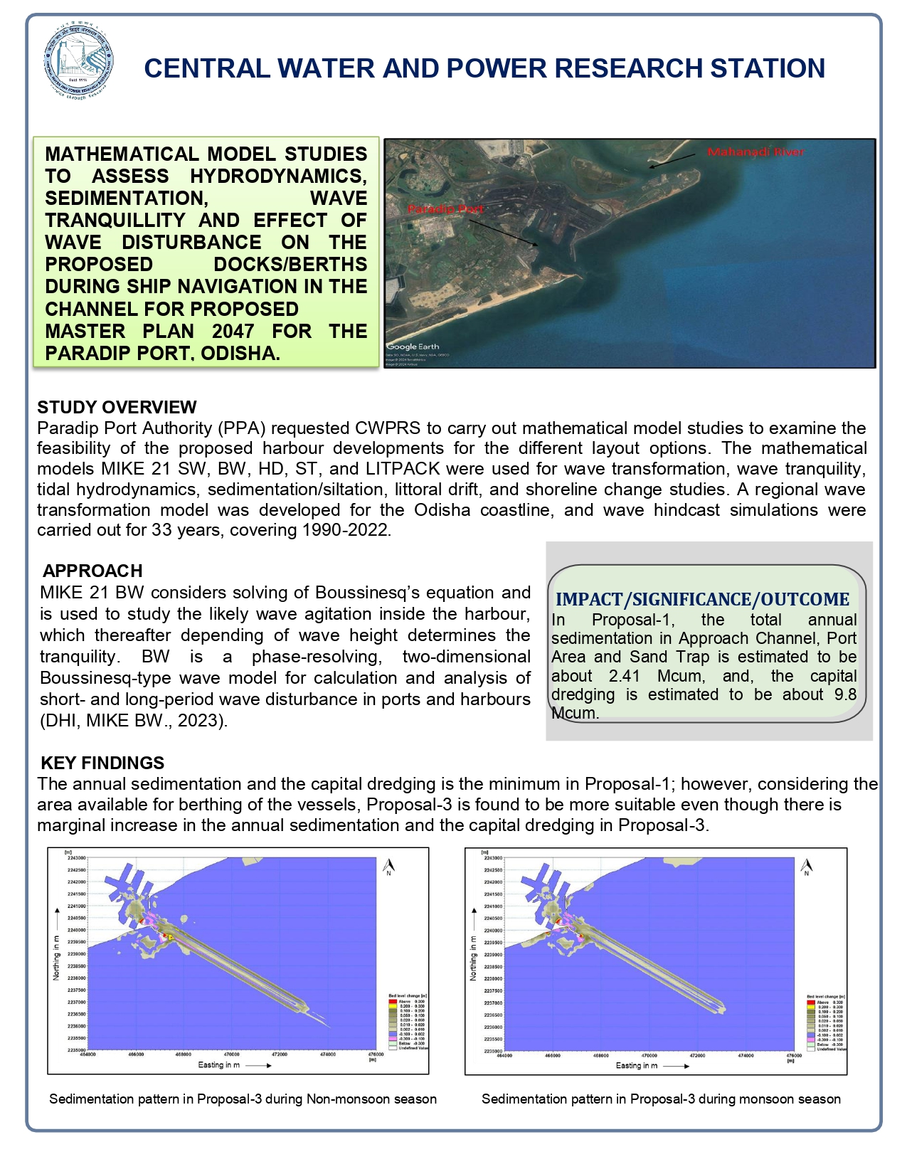
MATHEMATICAL MODEL STUDIES TO ASSESS HYDRODYNAMICS, SEDIMENTATION, WAVE TRANQUILLITY AND EFFECT OF WAVE DISTURBANCE ON THE PROPOSED DOCKS/BERTHS DURING SHIP NAVIGATION IN THE CHANNEL FOR PROPOSED MASTER PLAN 2047 FOR THE PARADIP PORT, ODISHA

Download
 Research Highlights Image

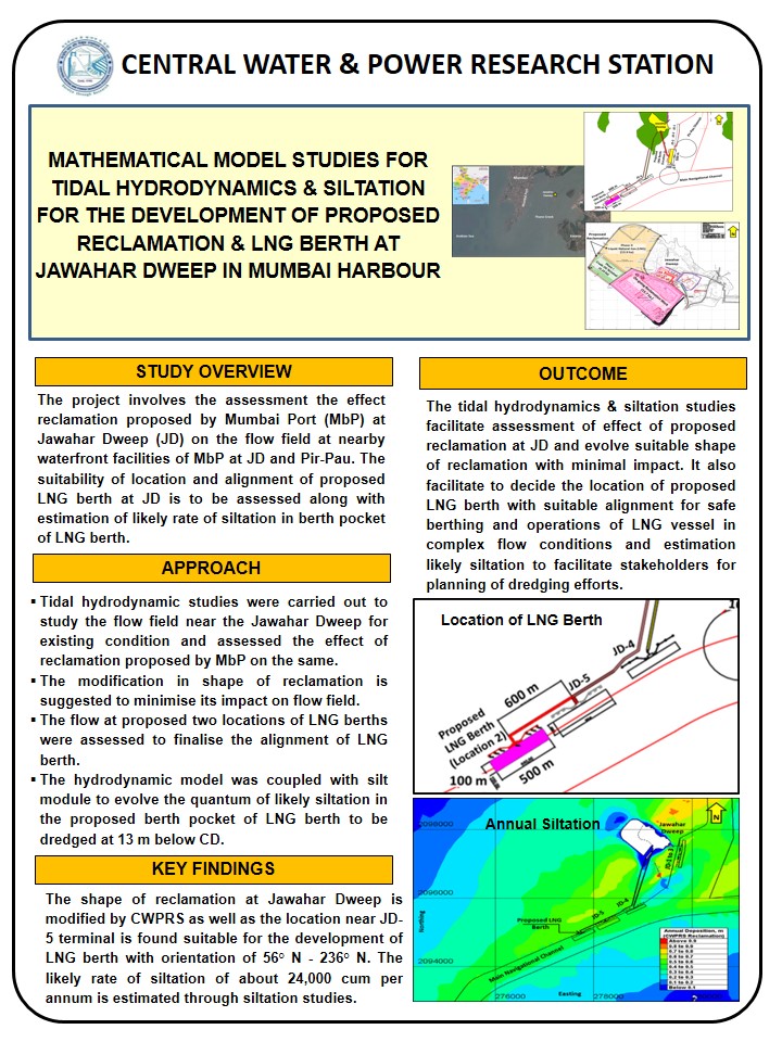
MATHEMATICAL MODEL STUDIES FOR TIDAL HYDRODYNAMICS & SILTATION FOR THE DEVELOPMENT OF PROPOSED RECLAMATION & LNG BERTH AT JAWAHAR DWEEP IN MUMBAI HARBOUR

Download
 Research Highlights Image

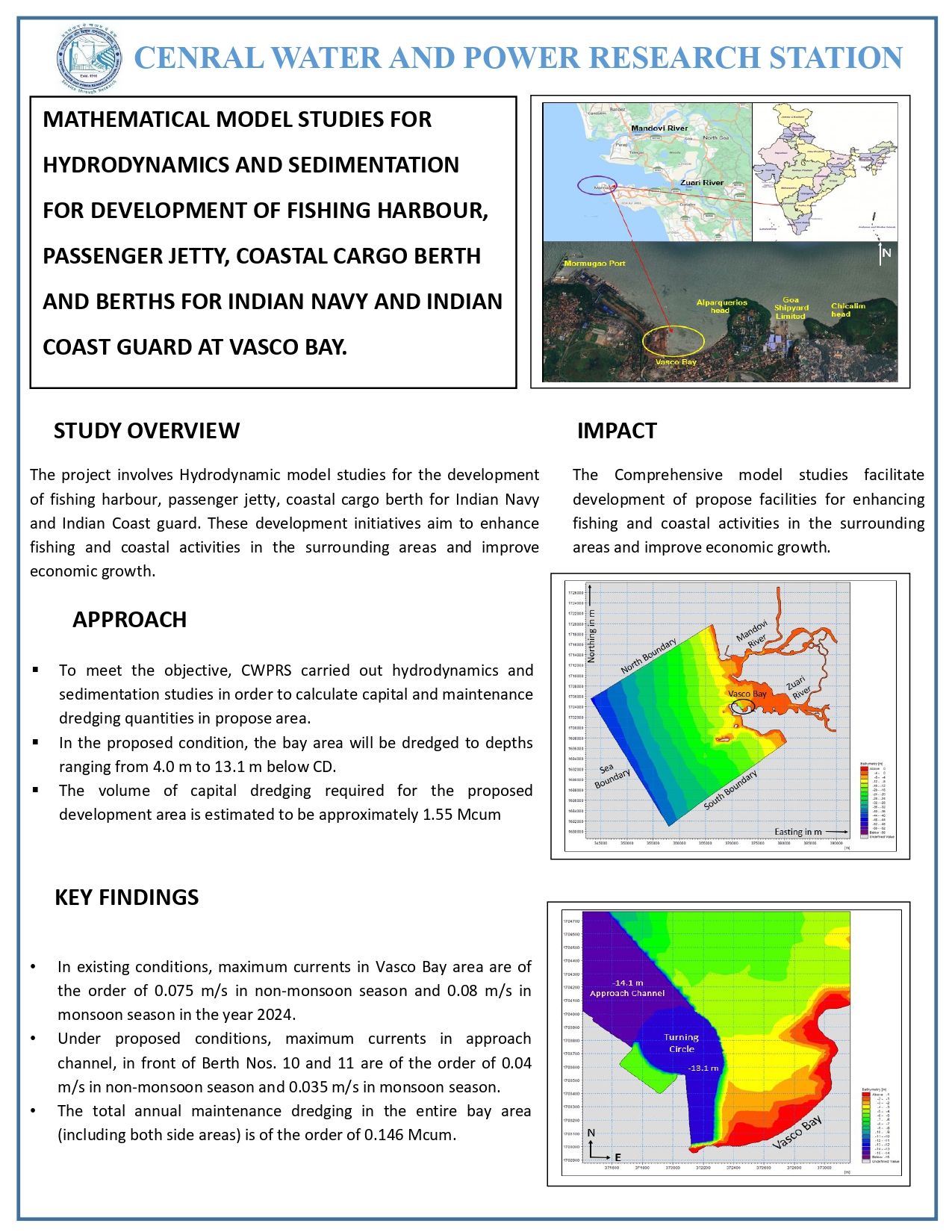
MATHEMATICAL MODEL STUDIES FOR HYDRODYNAMICS AND SEDIMENTATION FOR DEVELOPMENT OF FISHING HARBOUR, PASSENGER JETTY, COASTAL CARGO BERTH AND BERTHS FOR INDIAN NAVY AND INDIAN COAST GUARD AT VASCO BAY

Download
 Research Highlights Image

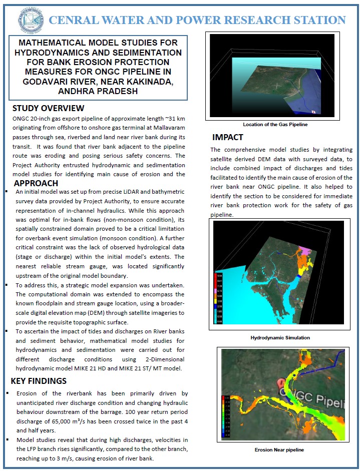
MATHEMATICAL MODEL STUDIES FOR HYDRODYNAMICS AND SEDIMENTATION FOR BANK EROSION PROTECTION MEASURES FOR ONGC PIPELINE IN GODAVARI RIVER, NEAR KAKINADA, ANDHRA PRADESH

Download
 Research Highlights Image

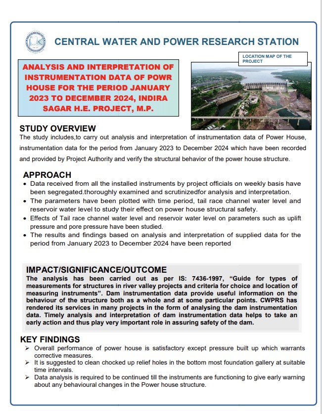
ANALYSIS AND INTERPRETATION OF INSTRUMENTATION DATA OF POWR HOUSE FOR THE PERIOD JANUARY 2023 TO DECEMBER 2024, INDIRA SAGAR H.E. PROJECT, M.P

Download
 Research Highlights Image

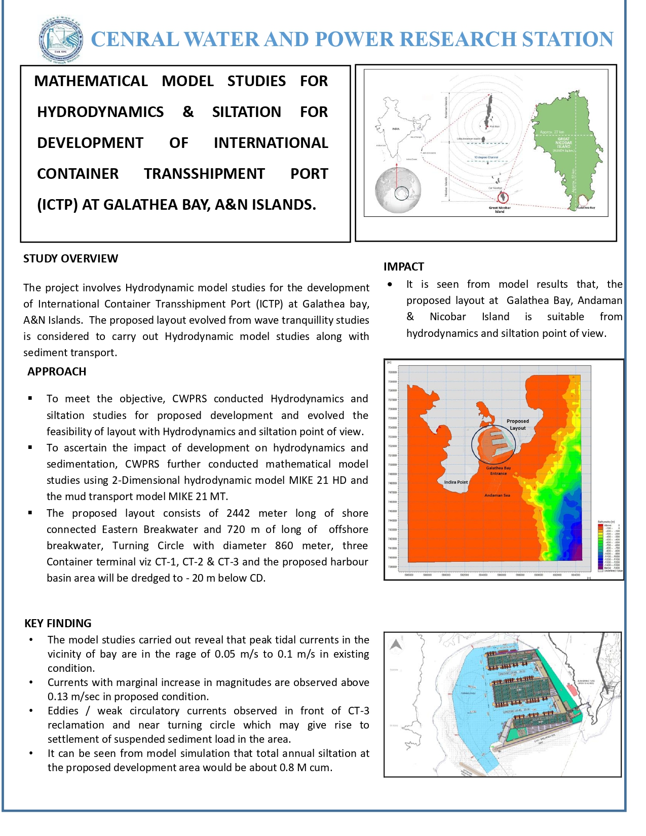
MATHEMATICAL MODEL STUDIES FOR HYDRODYNAMICS & SILTATION FOR DEVELOPMENT OF INTERNATIONAL CONTAINER TRANSSHIPMENT PORT (ICTP) AT GALATHEA BAY, A&N ISLANDS

Download
About Us Facilities Projects Publications Work Force Gallery

                                                                              ADCP installation in Sea
                                                                              Beach Survey
                                                                              Deploying PTG
                                                                              River ADCP
                                                                              River ADCP2
                                                                              Bed Samaple_collection
                                                                              Instruments
                                                                              LISST installation
                                                                              River ADCP1
                                                                              Tide gauge installation

The division specializes in prototype data collection and analysis, unlocking the secrets of dynamic coastal environments with precision and expertise. Sophisticated equipments are used to collect a wealth of coastal parameters. From the rhythmic dance of waves to the ebb and flow of tides, every nuance of coastal dynamics is captured. Further, River Acoustic Doppler Current Profilers (ADCPs) quantify river discharge, providing invaluable insights into the interaction between freshwater inflows and coastal environments. Continuous and comprehensive beach surveys carried out by this division is providing the required understanding, guiding the design and implementation of effective protection works to safeguard our coastal communities and ecosystems. In this division, data illuminates the path forward, where every measurement tells a story of resilience and adaptation along our dynamic coastlines. At Coastal Data Centre, the power of data transforms the understanding of coastal environments.

Broad Areas of Expertise

Coastal Data Centre extends its support and services to various coastal divisions of CWPRS for collecting the field data of Indian Coast. The coastal parameters being collected are

  • Wave height, direction & period
  • Tidal Currents and it’s profiling
  • Tidal level
  • Bathymetry
  • Conductivity, Temperature profile with Depth
  • Depth & Positioning
  • Suspended sediment size
  • River discharge
  • Meteorological Data
  • Beach Survey

Preventive Maintenance, Pre & Post tour maintenance is being carried out for the equipment. Additionally, mooring for the installation of field data collection equipment is prepared by the division.

Significant Contributions

  • Thermal mapping in the vicinity of Tarapur Atomic Power Station (TAPS) has been carried out as baseline information as well as input for the studies regarding assessment of the probable impact on the existing cooling water system of TAPS due to the proposed development of Port at Vadhvan.
  • Carried out 35 years of meteorological data analysis for the development of proposed Nuclear Power Projects at Bargi, Kovvada, MithiVirdi, Kudankulam, Kumariya, Bhimpur and Banswara.
  • Carried out coastal data collection on various parameters viz. waves, tides, currents, suspended sediment concentration, characteristics of bed material etc. at various locations in Gulf of Khambhat, east coast and west coast of India.

                                                                              ADCP installation in Sea
                                                                              Beach Survey
                                                                              Deploying PTG
                                                                              River ADCP
                                                                              River ADCP2
                                                                              Bed Samaple_collection
                                                                              Instruments
                                                                              LISST installation
                                                                              River ADCP1
                                                                              Tide gauge installation

Coastal Field Instrumentation division is presently equipped with State of Art equipment as described:

  • Directional Waverider Buoys- To measure wave characteristics using wave motion sensor based on a stabilized platform, accelerometers, and magnetic compass. Measures wave height for wave periods of 1.6 to 30s, accuracy 0.5% of the measured value, wave direction and water temperature. The collected wave data and GPS information are transmitted to a land based receiving station over a HF link and also on GSM network.
  • Marine Acoustic Doppler Profilers- ADCPs with 4 and 5 beam solutions to measure Water velocity and direction across a water column. Wave parameters can also be measured using the 5th beam. Velocity Range is ±5 meter/second with an accuracy of ±0.5% of the measured value.   Profiling range is 50 meters.
  • River Acoustic Doppler Profilers- For river discharges near coastal regions.
  • Bathymetric Survey System- For collection of nearshore bathymetry data.
  • Automatic Weather Station- For meteorological parameters collection like wind speed & Direction, relative humidity, rainfall etc.
  • Impeller Current Meters- For point water velocity up to ±5 meter/second with direction.
  • Pressure Tide Gauges- To measure Water level  upto 100 meters and has an internal data logger to store upto 90 days data.
  • LISST- For suspended sediments data in sea and estuary.
  • Water Sampler and Grab sampler-For suspended and bed sediment characterstics.
  • Total station: For beach Survey and profiling.
  • CTD Meter- For Salinity temperature and depth measurement.
  • Acoustic Release with command unit- Used as ancillary equipment for safe retrieval of deployed instruments.

Coastal data centre has conducted field data collection campaigns for many sites, a few of them are listed here under.

  • Dapoli, Ratnagiri, Maharashtra.
  • Anjarle, Ratnagiri Maharashtra.
  • Satpati, Palghar, Maharashtra and Nani Danti-Moti Danti, Gujrat.
  • Morbi, Gujrat.
  • JagannathPuri, Odisha.
  • Rajvardhan, Maharashtra.
  • Okha , Gujarat.
  • Aaravi, Anjarle and Guhaghar, Maharashtra.
  • Versova and Marve, Maharashtra.
  • Muthalapozhi, Kerala.
  • ParadipPort, Odisha.

  • J.A. Shimpi, S.G. Manjunatha, L.R. Ranganath (Retd.), K.B. Bobade, VivekSaxena, "Observation of Flow Pattern at Dahej in Gulf of Khambhat", 26th International Conference on "Hydraulics, Water Resources and Coastal Engineering (HYDRO-2021)", organized by Department of Civil Engineering, Sardar Vallabhbhai National Institute of Technology (SVNIT), Surat, Gujarat, under the aegis of The Indian Society for Hydraulics (ISH), Pune, during 23-25 December 2021 at SVNIT, Surat, Gujarat.
  • K.B. Bobade, S.G. Manjunatha, "Characteristics and Frequency Analysis of Annual Maximum Rainfall at Surat, Gujarat, India", 26th International Conference on "Hydraulics, Water Resources and Coastal Engineering (HYDRO-2021)", organized by Department of Civil Engineering, Sardar Vallabhbhai National Institute of Technology (SVNIT), Surat, Gujarat, under the aegis of The Indian Society for Hydraulics (ISH), Pune, during 23-25 December 2021 at SVNIT, Surat, Gujarat.

Serial No. Name Designation Email Id Phone Number
1 Shri S. G. Manjunatha SCIENTIST-E and HoD (CDC) manjunatha[dot]sg[at]cwprs[dot]gov[dot]in 020-24103415
2 Shri G. V. Ramanarao SCIENTIST-E and HoD (CFI) ramanarao[underscore]gv[at]cwprs[dot]gov[dot]in 020-24103479
3 Shri J. A. Shimpi SCIENTIST-D Shimpi[dot]j[at]cwprs[dot]gov[dot]in 020-24103512
4 Shri Y. R. Bhagat SCIENTIST-C bhagat[dot]yr[at]cwprs[dot]gov[dot]in 020-24103430
5 Shri K. B. Bobade SCIENTIST-C bobde[dot]kb[at]cwprs[dot]gov[dot]in 020-24103301
6 Smt A. A. Sonavane SCIENTIST-B anuradha[dot]as[at]cwprs[dot]gov[dot]in 020-24103480
8 Shri Subodh Kumar ARO subodh[dot]kumar[at]cwprs[dot]gov[dot]in 020-24103480
7 Shri Vivek Saxena RA (ENGR.) vivek[dot]saxena[at]cwprs[dot]gov[dot]in 020-24103480
9 Shri S. D. Mourya AE sanjay[dot]mourya[at]cwprs[dot]gov[dot]in 020-24103480
10 Shri Babaji. R. Thopate CRF ‘D’ (ex. serviceman) thopte[dot]br[at]cwprs[dot]gov[dot]in 020-24103480
11 Shri A. A.I. Shaikh MTS  akil[dot]shaikh[at]cwprs[dot]gov[dot]in 020-24103480
12 Shri Rahul Singh Bohra MTS rahul[dot]bohra[at]cwprs[dot]gov[dot]in 020-24103480

                                                                              ADCP installation in Sea

ADCP installation in Sea

                                                                              Beach Survey

Beach Survey

                                                                              Deploying PTG

Deploying PTG

                                                                              River ADCP

River ADCP

                                                                              River ADCP2

River ADCP2

                                                                              Bed Samaple_collection

Bed Samaple_collection

                                                                              Instruments

Instruments

                                                                              LISST installation

LISST installation

                                                                              River ADCP1

River ADCP1

                                                                              Tide gauge installation

Tide gauge installation

cwc logo
digital india
india gov
online voters
cmis logo
csmrs logo

Central Water & Power Research Station(CWPRS)

Khadakwasla

Maharashtra Pune-411024 India

Tel : +91(20)24103200/24381801  
Email: director[at]cwprs[dot]gov[dot]in

Important links

  • Terms & Conditions
  • Content Review (CRP) policy
  • Privacy Policy
  • Copyright Policy
  • Hyper linking Policy
  • Website Monitoring Plan
  • Contingency Management Plan
  • Security Policy
  • Web Information Manager

Quick Links

  • Help
  • Gallery
  • Content Contribution, Moderation and Approval (CMAP) policy
  • Content Archival (CAP) policy
  • FAQ
  • Tenders
  • Contact Us
  •                        Valid CSS!
  •                        CQW logo
  •                        India Gov In
  •  STQC logo

Total Visitors:341754

Today's Visitors: 803

(Since 18-12-2024)

Last updated on : 27/01/2026

© Copyright © 2024 - Content owned by Central Water and Power Research Station (CWPRS), Developed, hosted, and maintained by ADG Online Solutions Pvt. Ltd.

  • Instagram