


Disciplines
Research Highlights
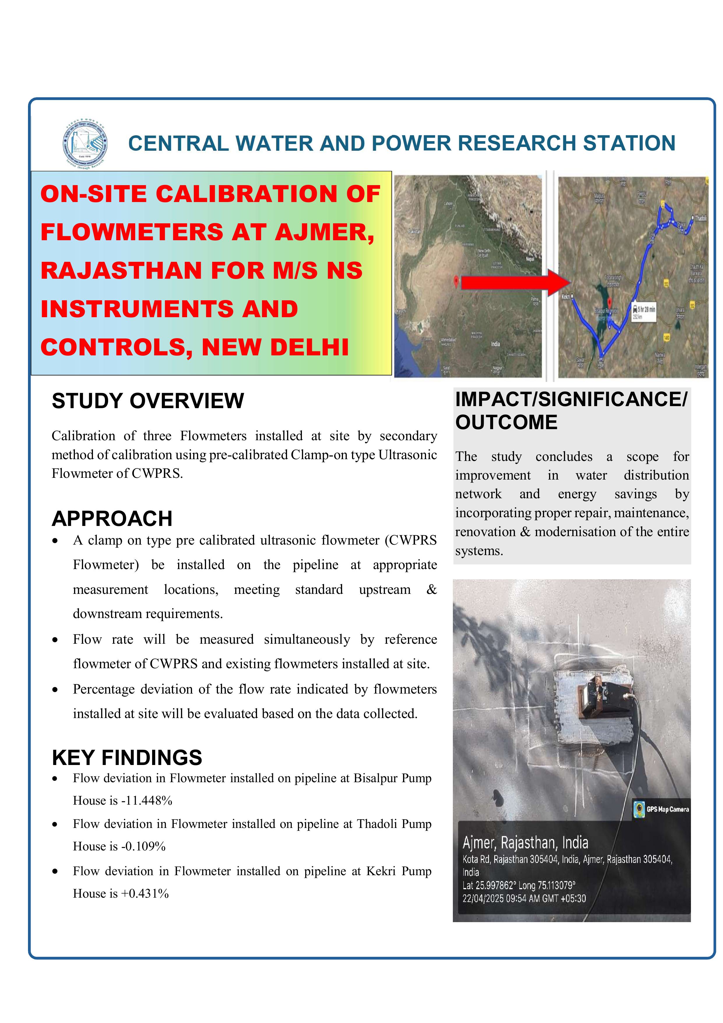
ON-SITE CALIBRATION OF FLOWMETERS AT AJMER, RAJASTHAN FOR M/S NS INSTRUMENTS AND CONTROLS, NEW DELHI
Download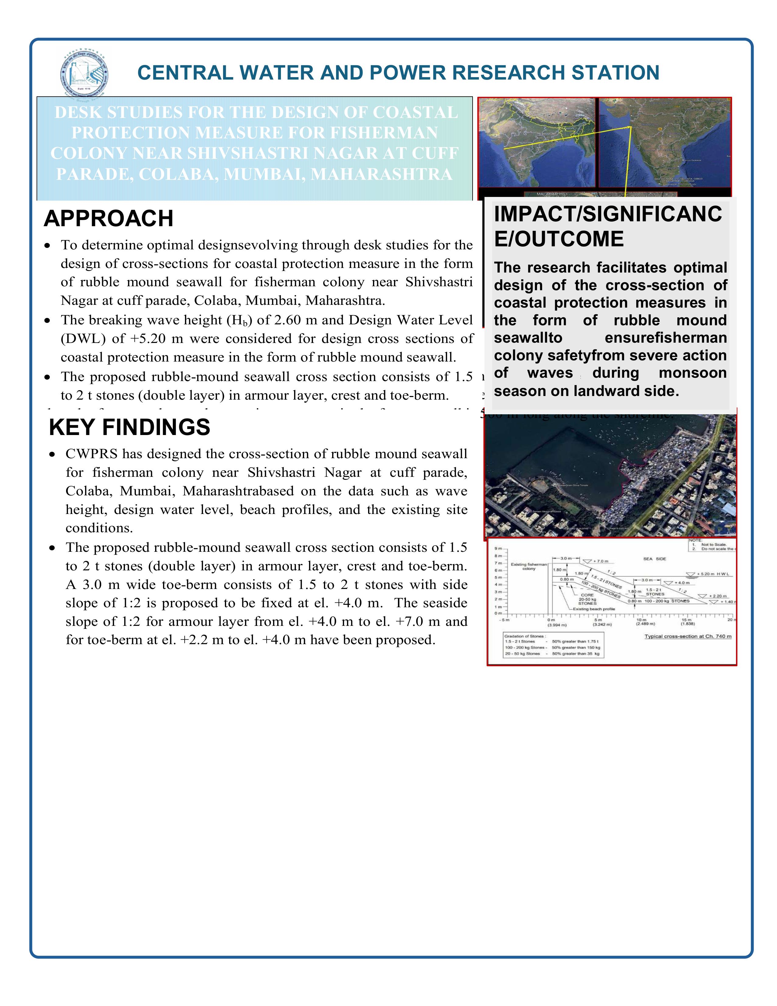
DESK STUDIES FOR THE DESIGN OF COASTAL PROTECTION MEASURE FOR FISHERMAN COLONY NEAR SHIVSHASTRI NAGAR AT CUFF PARADE, COLABA, MUMBAI, MAHARASHTRA
Download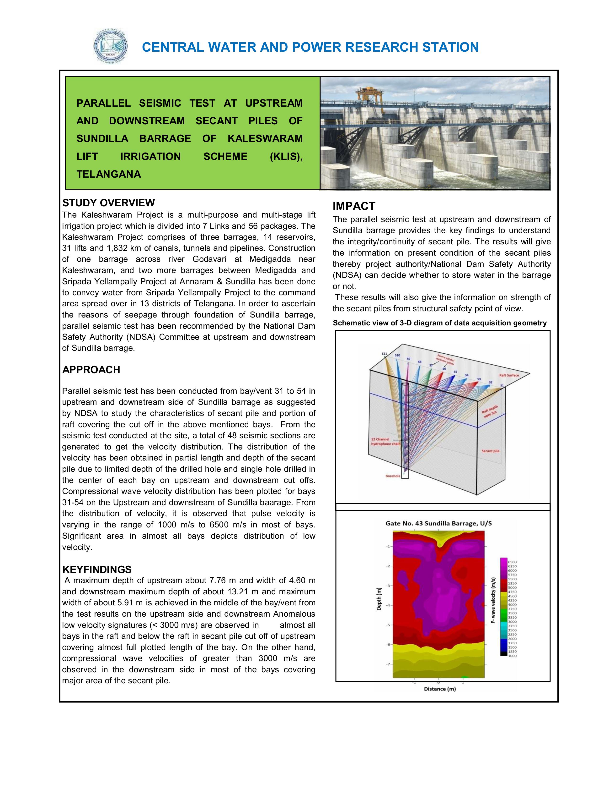
PARALLEL SEISMIC TEST AT UPSTREAM AND DOWNSTREAM SECANT PILES OF SUNDILLA BARRAGE OF KALESWARAM LIFT IRRIGATION SCHEME (KLIS), TELANGANA
Download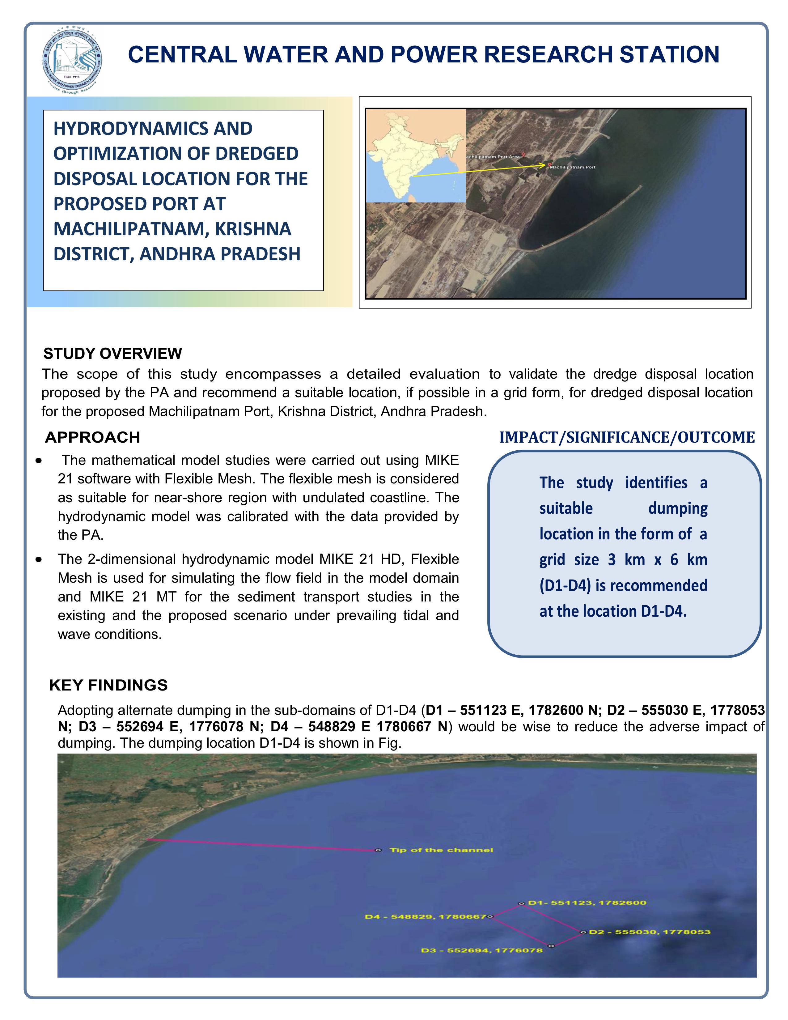
HYDRODYNAMICS AND OPTIMIZATION OF DREDGED DISPOSAL LOCATION FOR THE PROPOSED PORT AT MACHILIPATNAM, KRISHNA DISTRICT, ANDHRA PRADESH
Download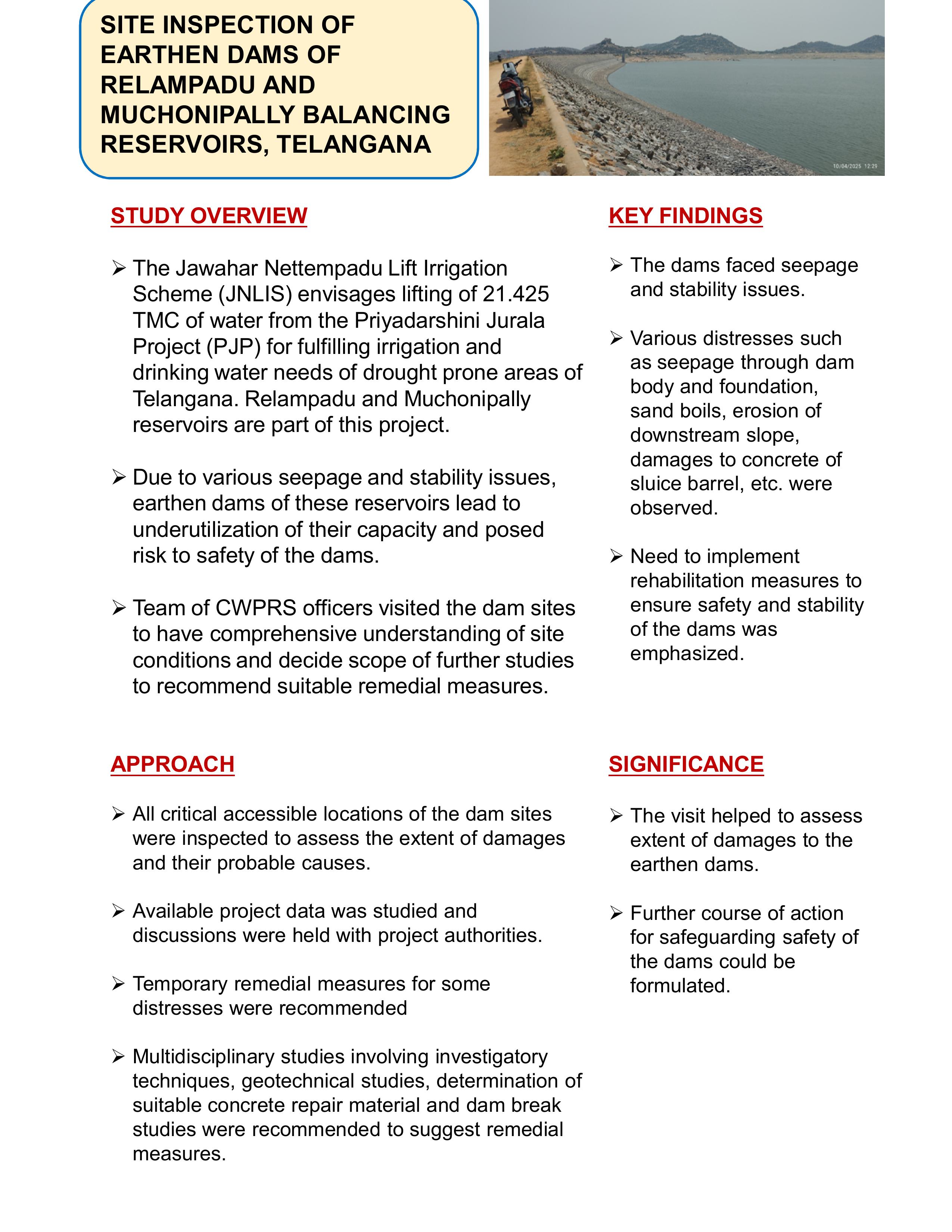
SITE INSPECTION OF EARTHEN DAMS OF RELAMPADU AND MUCHONIPALLY BALANCING RESERVOIRS, TELANGANA
Download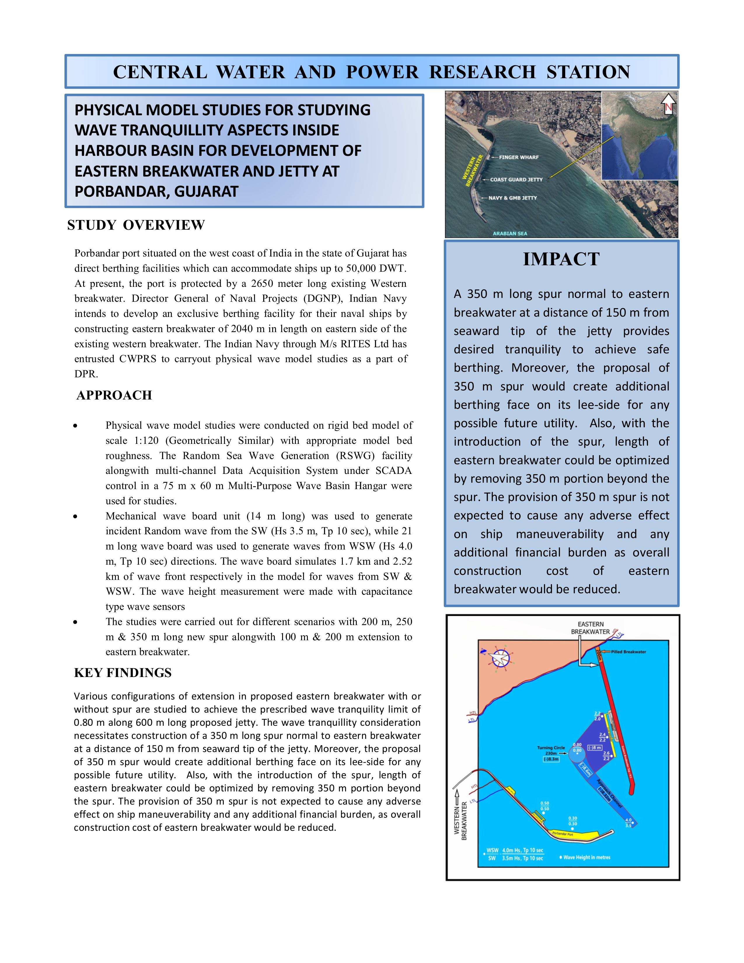
PHYSICAL MODEL STUDIES FOR STUDYING WAVE TRANQUILLITY ASPECTS INSIDE HARBOUR BASIN FOR DEVELOPMENT OF EASTERN BREAKWATER AND JETTY AT PORBANDAR, GUJARAT
Download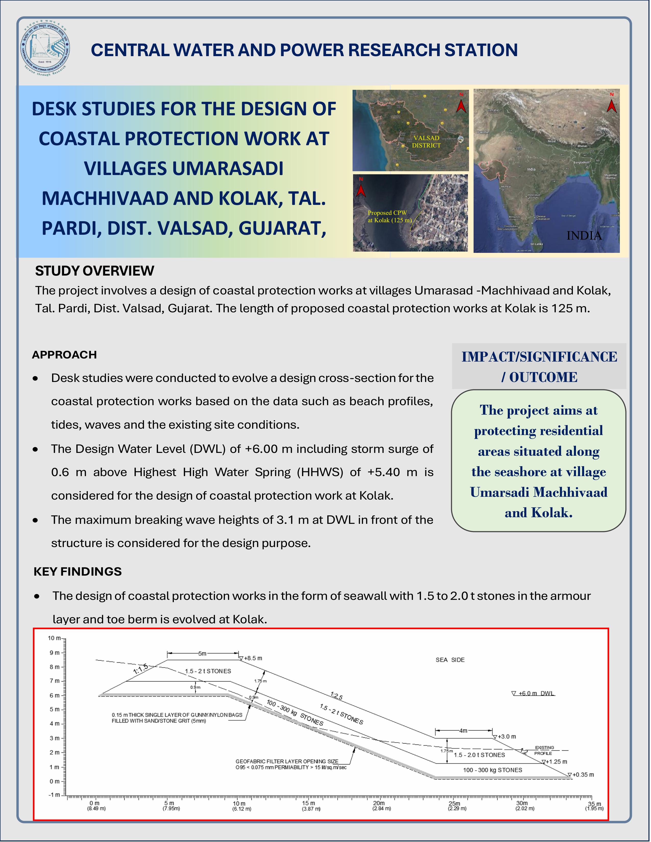
DESK STUDIES FOR DESIGN OF COASTAL PROTECTION WORK AT VILLAGES UMARASADI, MACHHIWAAD, AND KOLAK, TAL. PARDI, DIST. VALSAD, GUJARAT
Download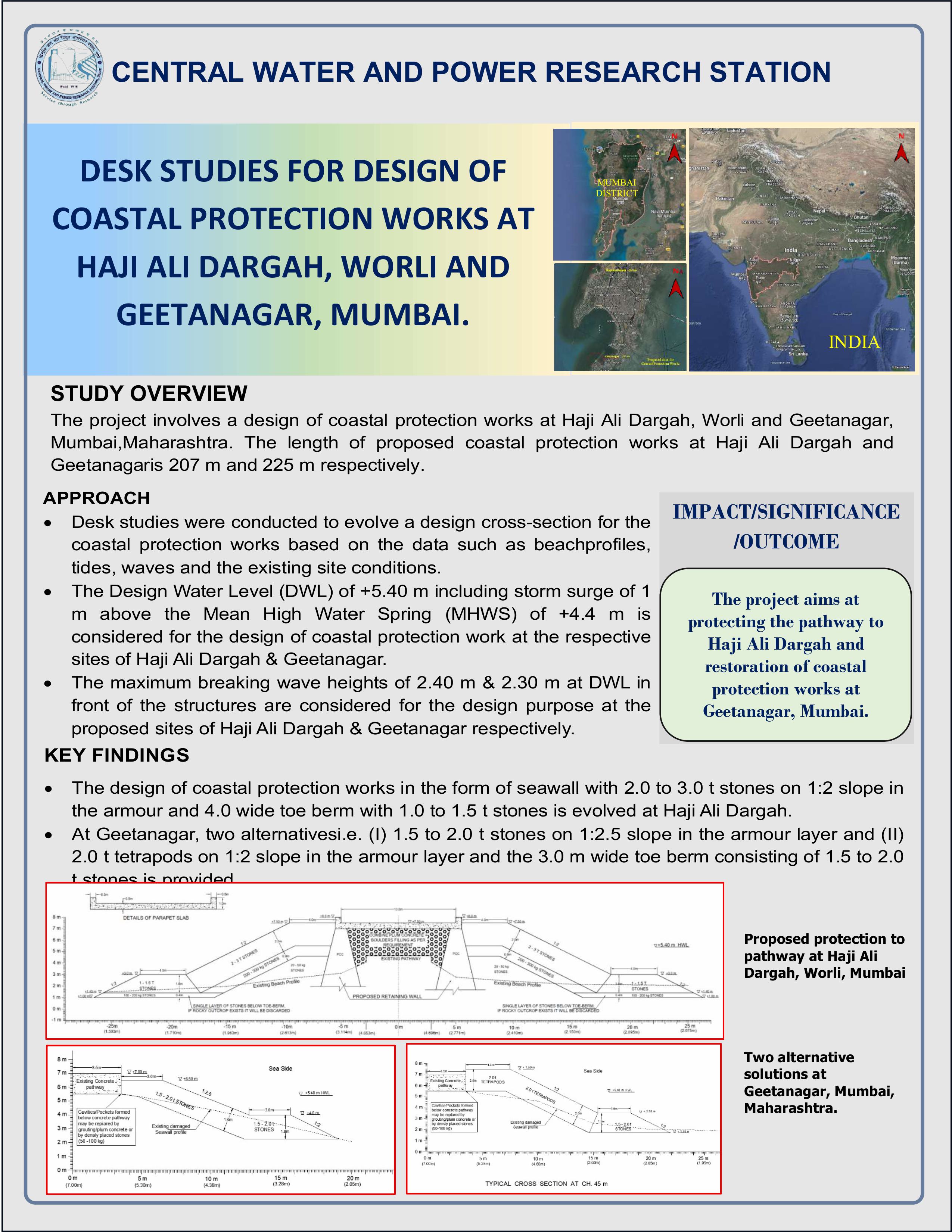
DESK STUDIES FOR DESIGN OF COASTAL PROTECTION WORKS AT HAJI ALI DARGAH, WORLI AND GEETANAGAR, MUMBAI
Download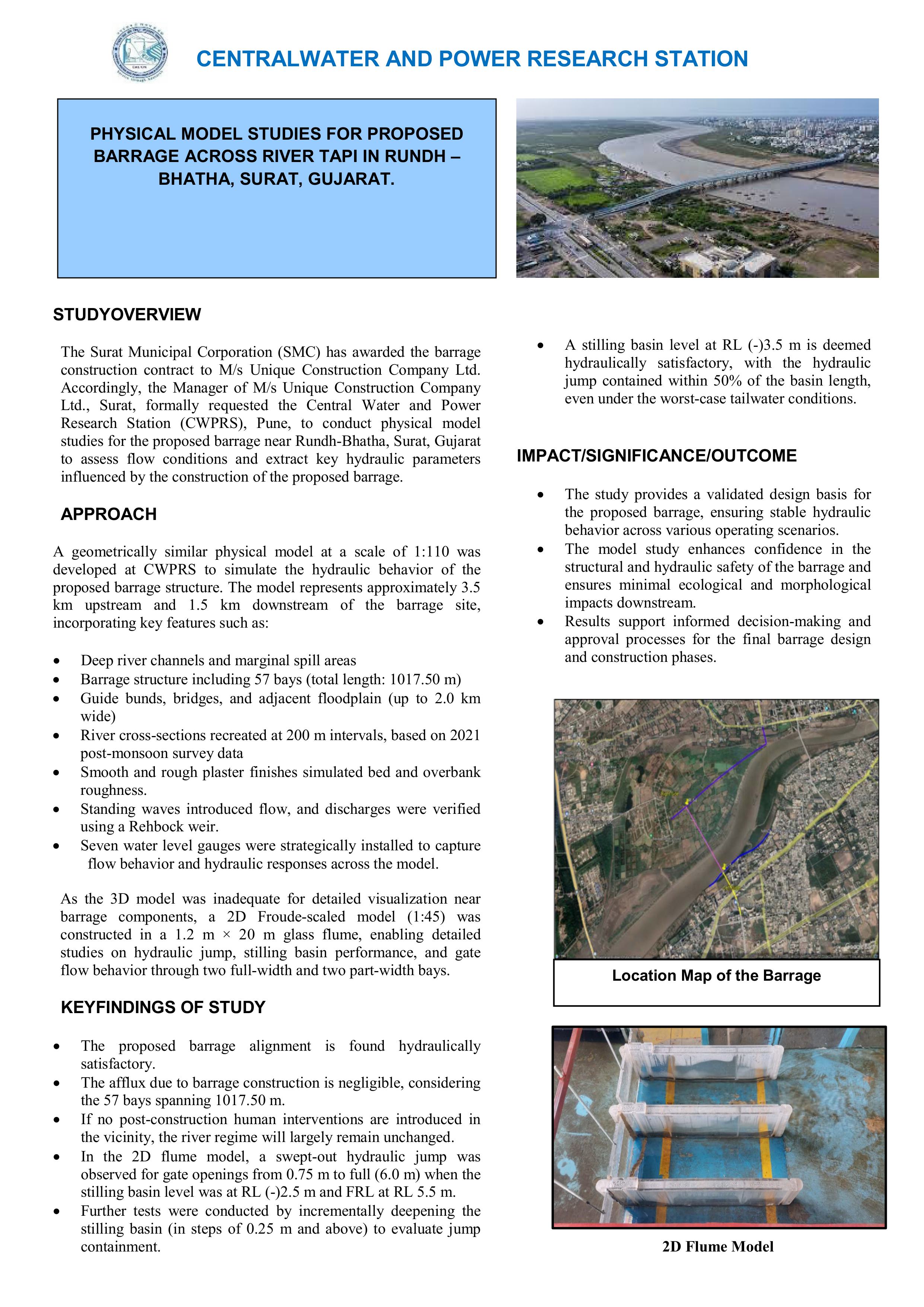
PHYSICAL MODEL STUDIES FOR PROPOSED BARRAGE ACROSS RIVER TAPI IN RUNDH - BHATHA, SURAT, GUJARAT
Download
The hydrological re-assessment involves evaluating water flow and flood risks for the 198 km new railway line project from Indore to Budhni in Madhya Pradesh, aimed at enhancing rail connectivity under the National Infrastructure Pipeline.
Download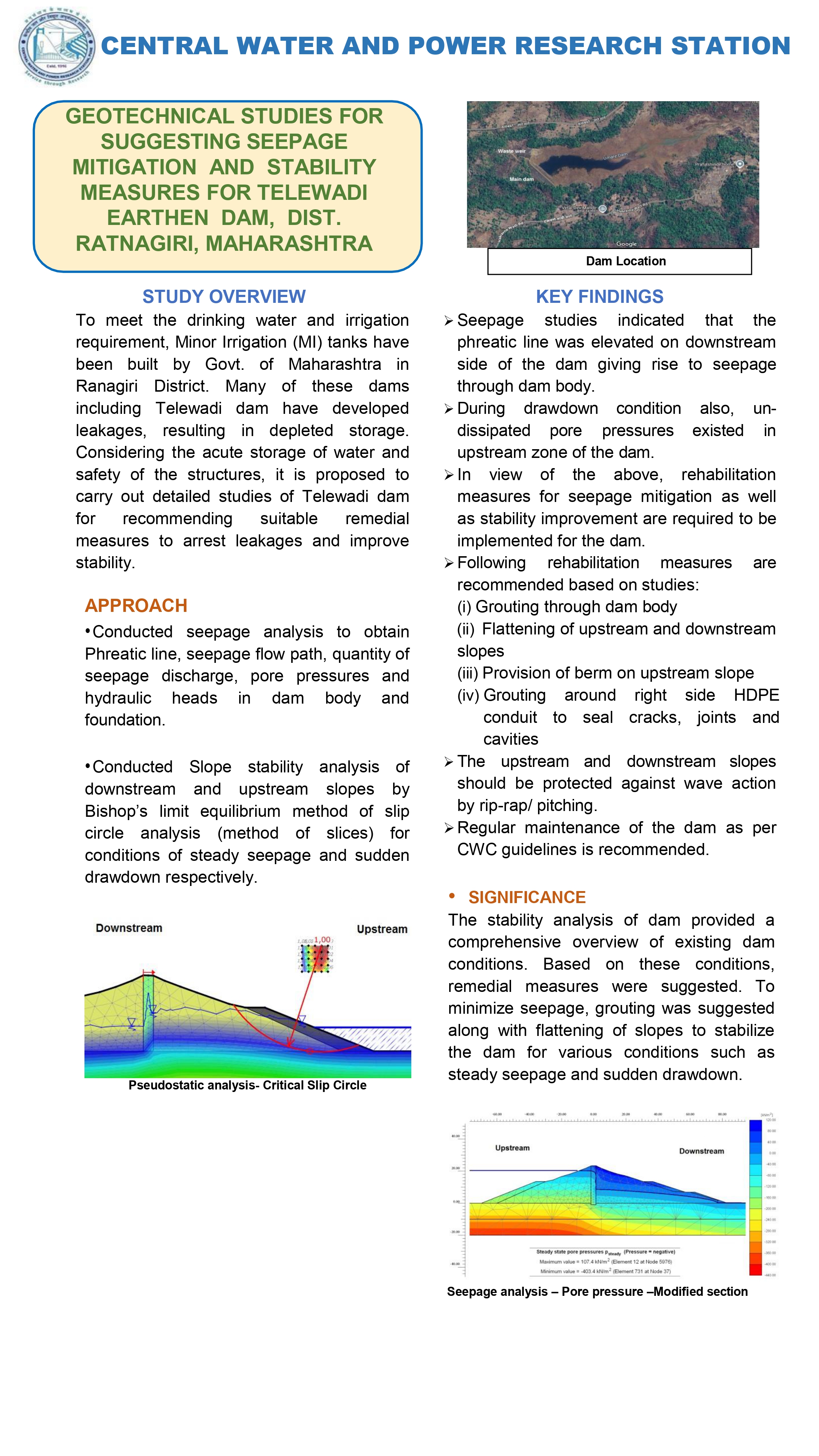
Geotechnical analysis to recommend measures for reducing seepage and enhancing stability of the Telewadi earthen dam, addressing safety concerns through soil and foundation assessments.
Download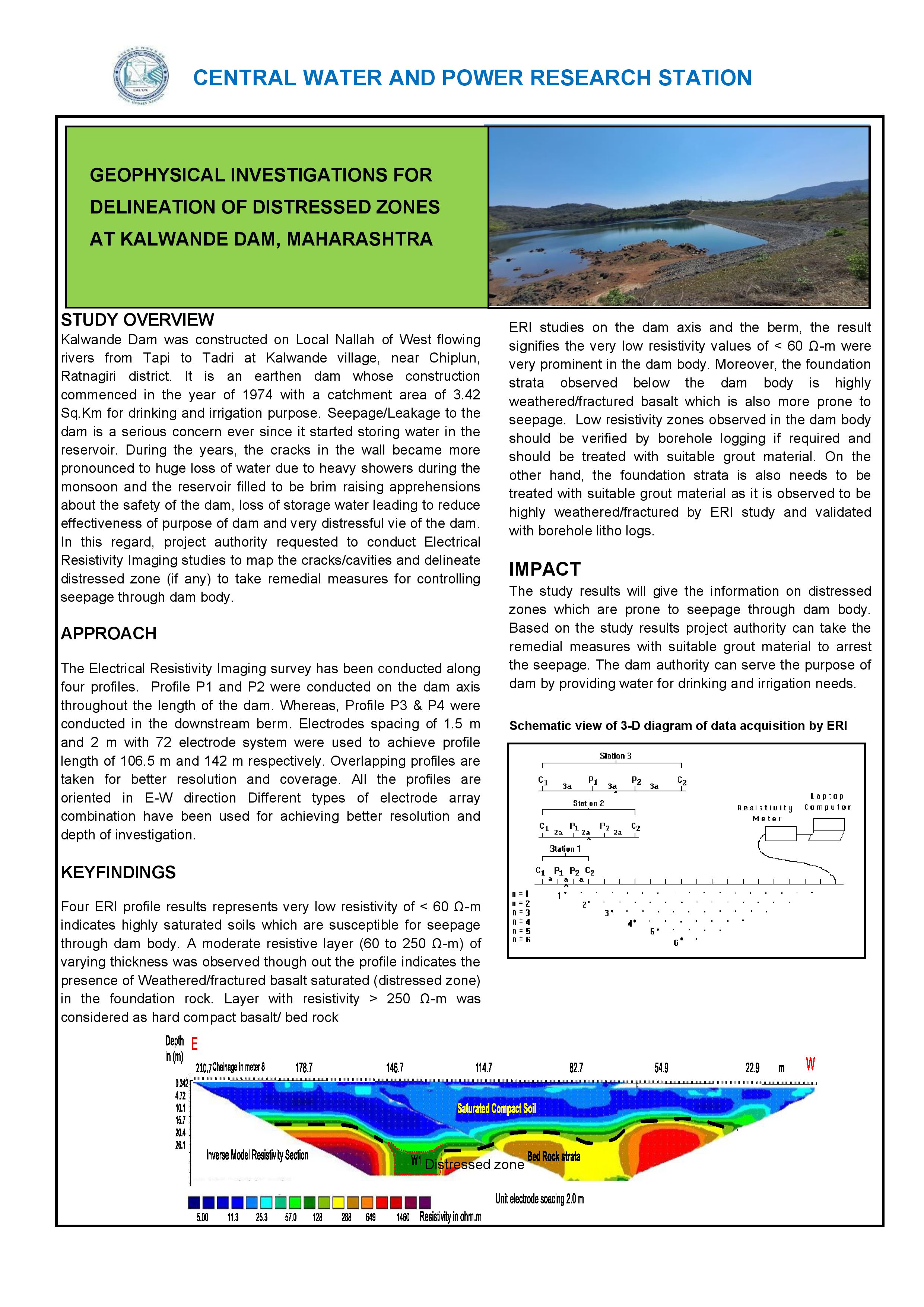
Geophysical surveys using seismic tomography and electrical resistivity to identify and map weak or distressed areas in the Kalwande Dam structure for targeted repairs.
Download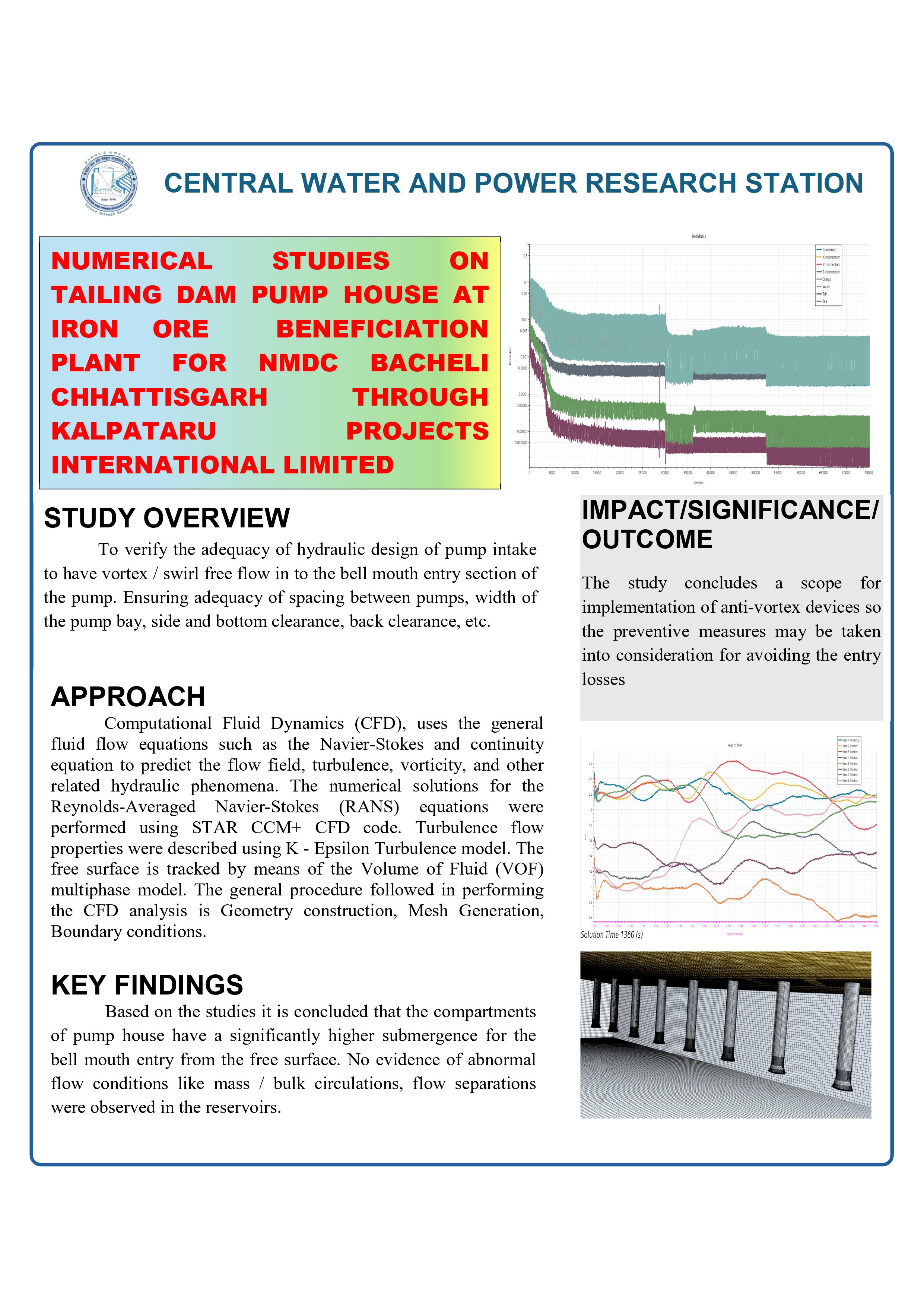
Numerical modeling to assess structural integrity and safety of the pump house at the tailing dam of NMDC's iron ore beneficiation plant in Bacheli, Chhattisgarh.
Download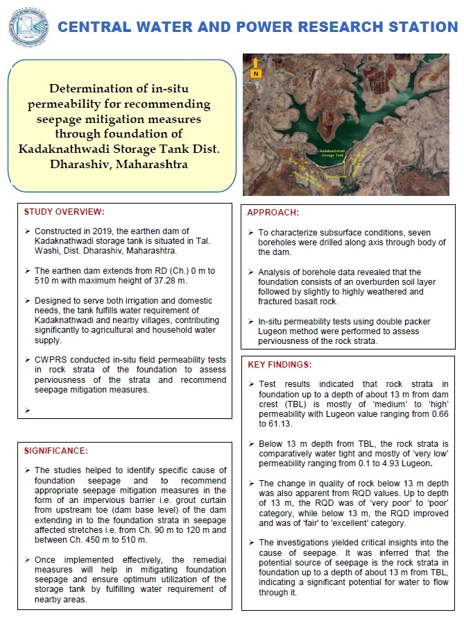
In-situ permeability testing to evaluate foundation seepage risks and propose mitigation strategies for the Kadaknathwadi storage tank in Dharashiv district.
Download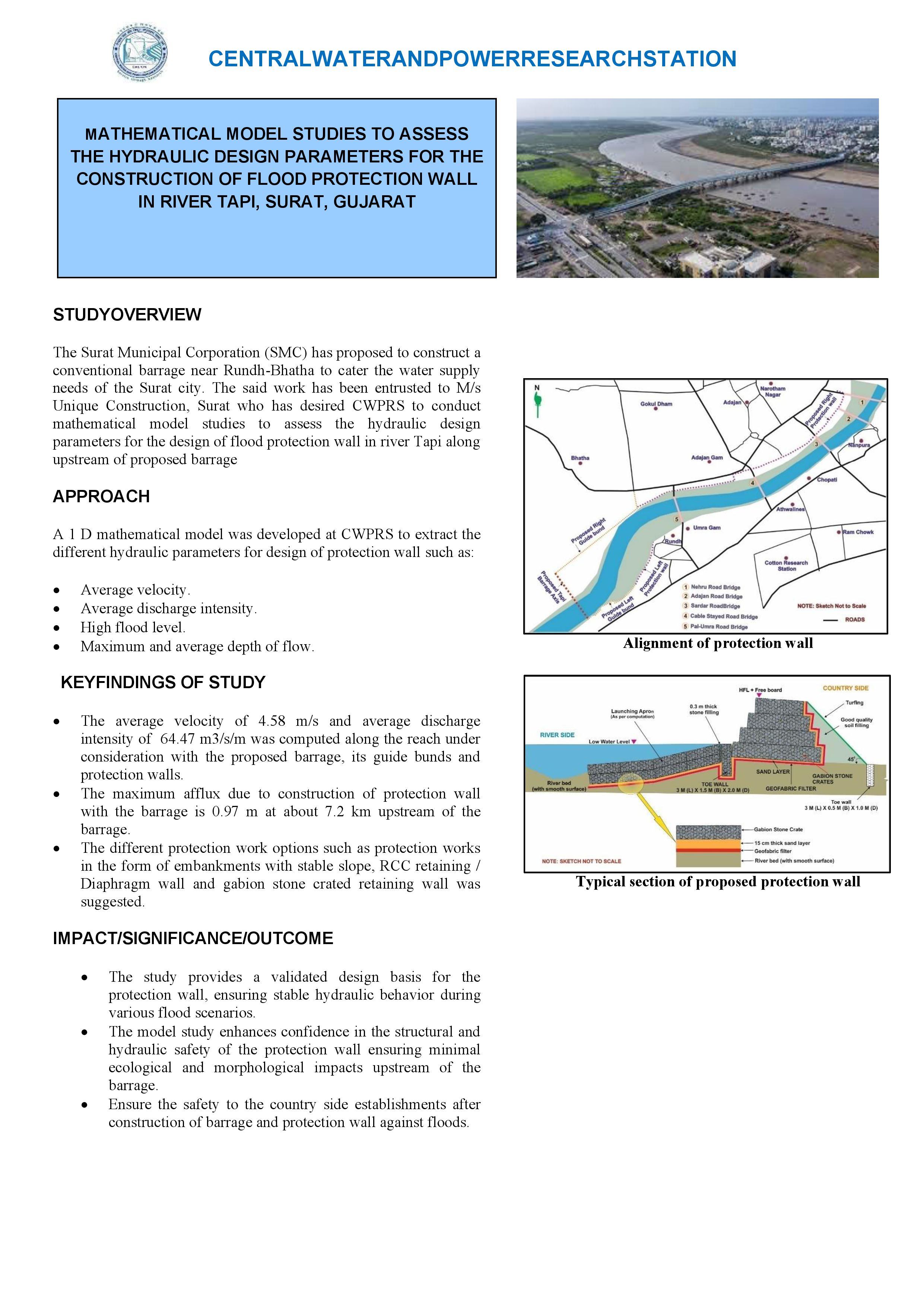
Mathematical modeling using HEC-RAS to determine hydraulic parameters for designing effective flood protection walls along the Tapi River in Surat to mitigate urban flooding.
Download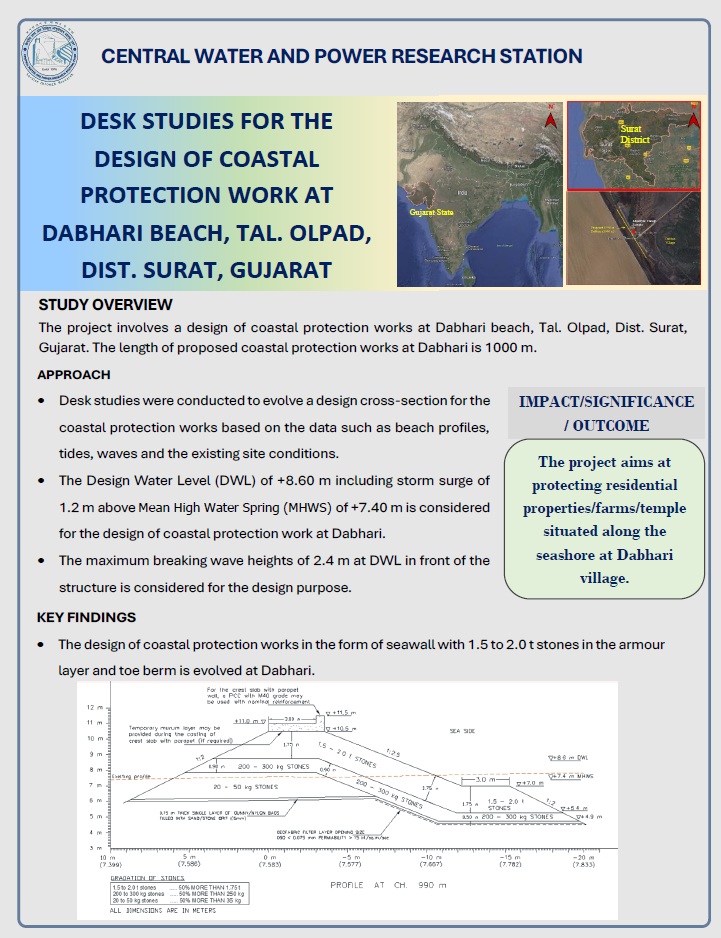
Desk-based analysis for planning coastal protection structures at Dabhari Beach to prevent erosion and support tourism and industrial development in the Olpad taluka area.
Download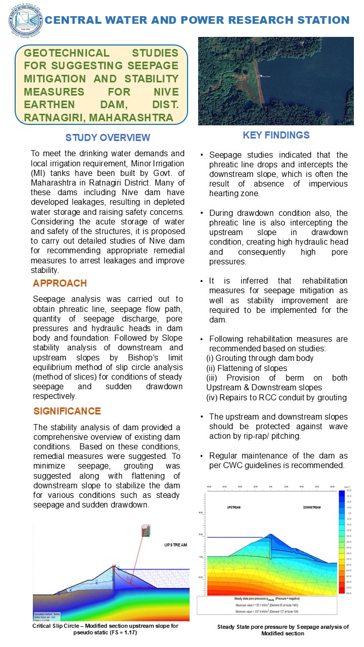
Geotechnical evaluation to propose seepage control and stability enhancements for the Nive earthen dam, ensuring long-term safety through soil mechanics analysis.
Download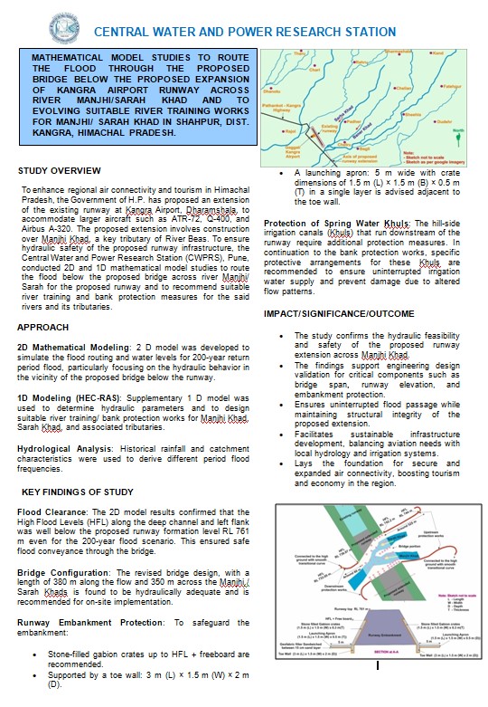
MATHEMATICAL MODEL STUDIES TO ROUTE THE FLOOD THROUGH THE PROPOSED BRIDGE BELOW THE PROPOSED EXPANSION OF KANGRA AIRPORT RUNWAY ACROSS RIVER MANJHI/SARAH KHAD AND TO EVOLVING SUITABLE RIVER TRAINING WORKS FOR MANJHI/ SARAH KHAD IN SHAHPUR, DIST. KANGRA, HIMACHAL PRADESH
Download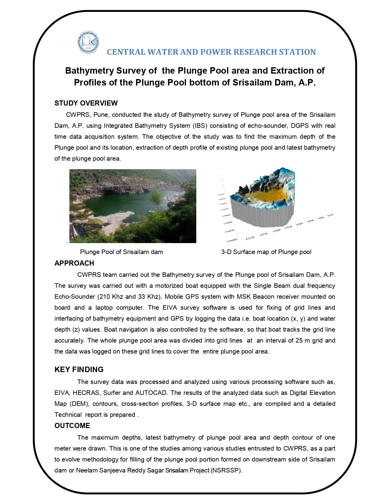
BATHYMETRY SURVEY OF THE PLUNGE POOL AREA AND EXTRACTION OF PROFILES OF THE PLUNGE POOL BOTTOM OF SRISAILAM DAM, A.P.
Download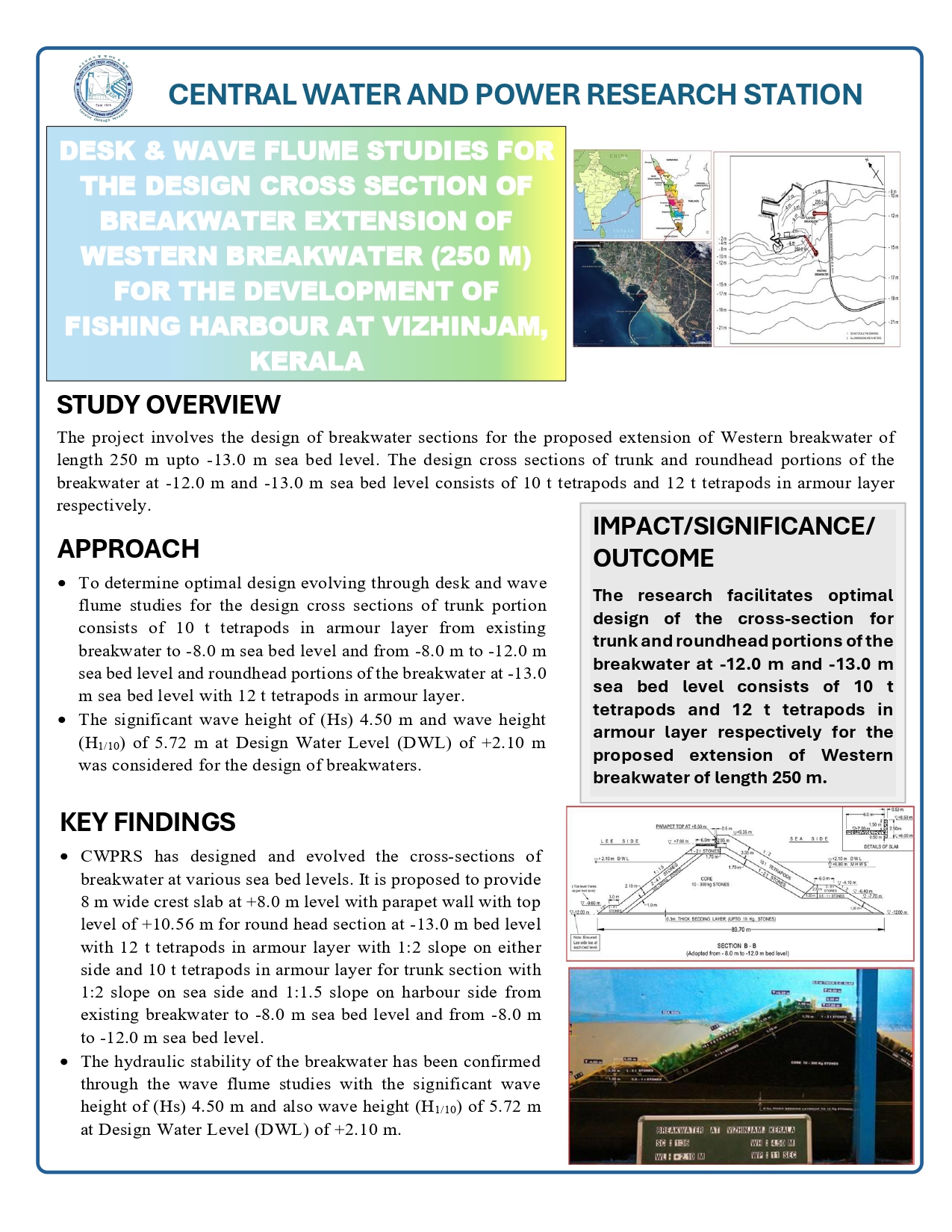
DESK & WAVE FLUME STUDIES FOR THE DESIGN CROSS SECTION OF BREAKWATER EXTENSION OF WESTERN BREAKWATER (250 M) FOR THE DEVELOPMENT OF FISHING HARBOUR AT VIZHINJAM, KERALA
Download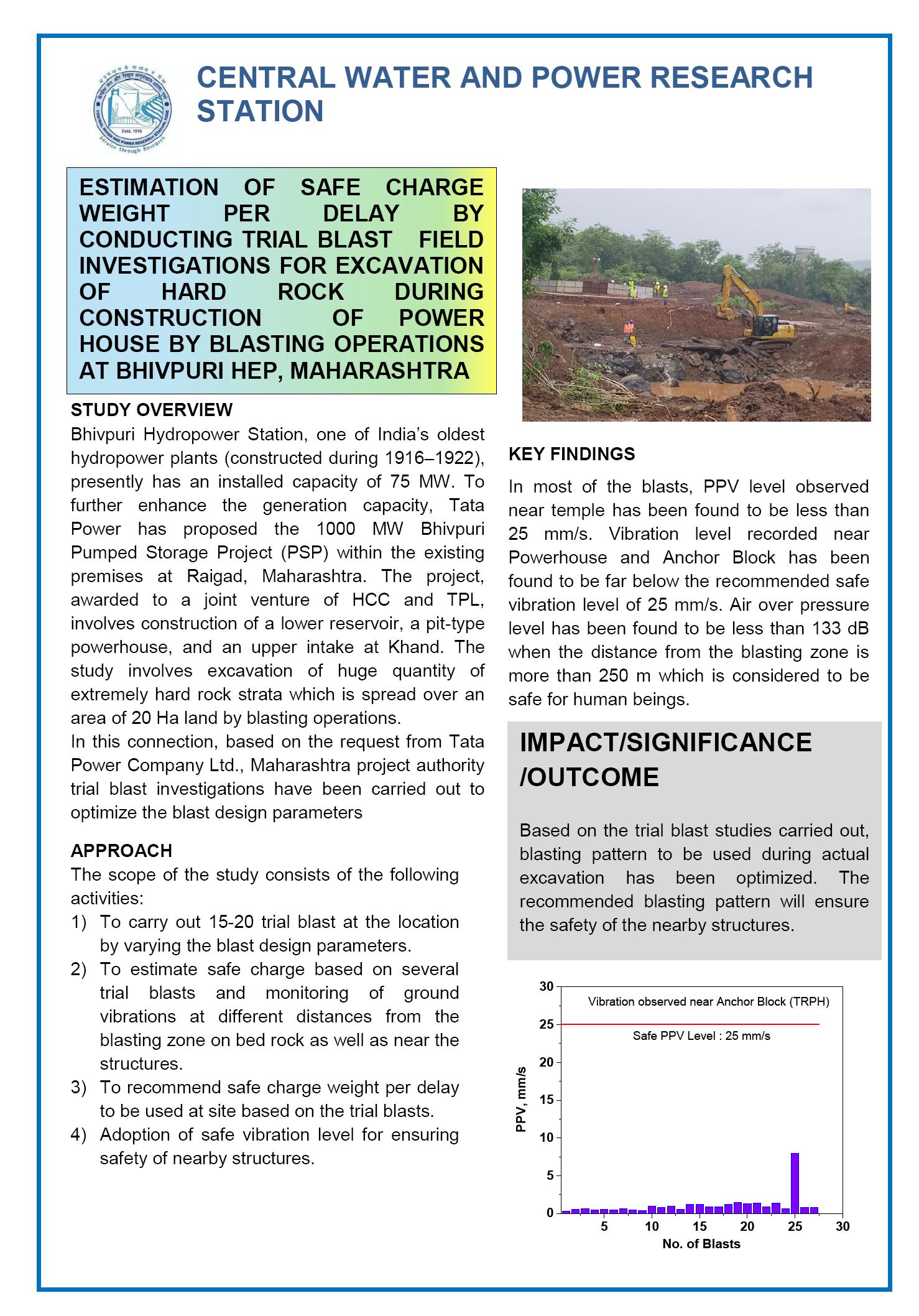
ESTIMATION OF SAFE CHARGE WEIGHT PER DELAY BY CONDUCTING TRIAL BLAST FIELD INVESTIGATIONS FOR EXCAVATION OF HARD ROCK DURING CONSTRUCTION OF POWER HOUSE BY BLASTING OPERATIONS AT BHIVPURI HEP, MAHARASHTRA
Download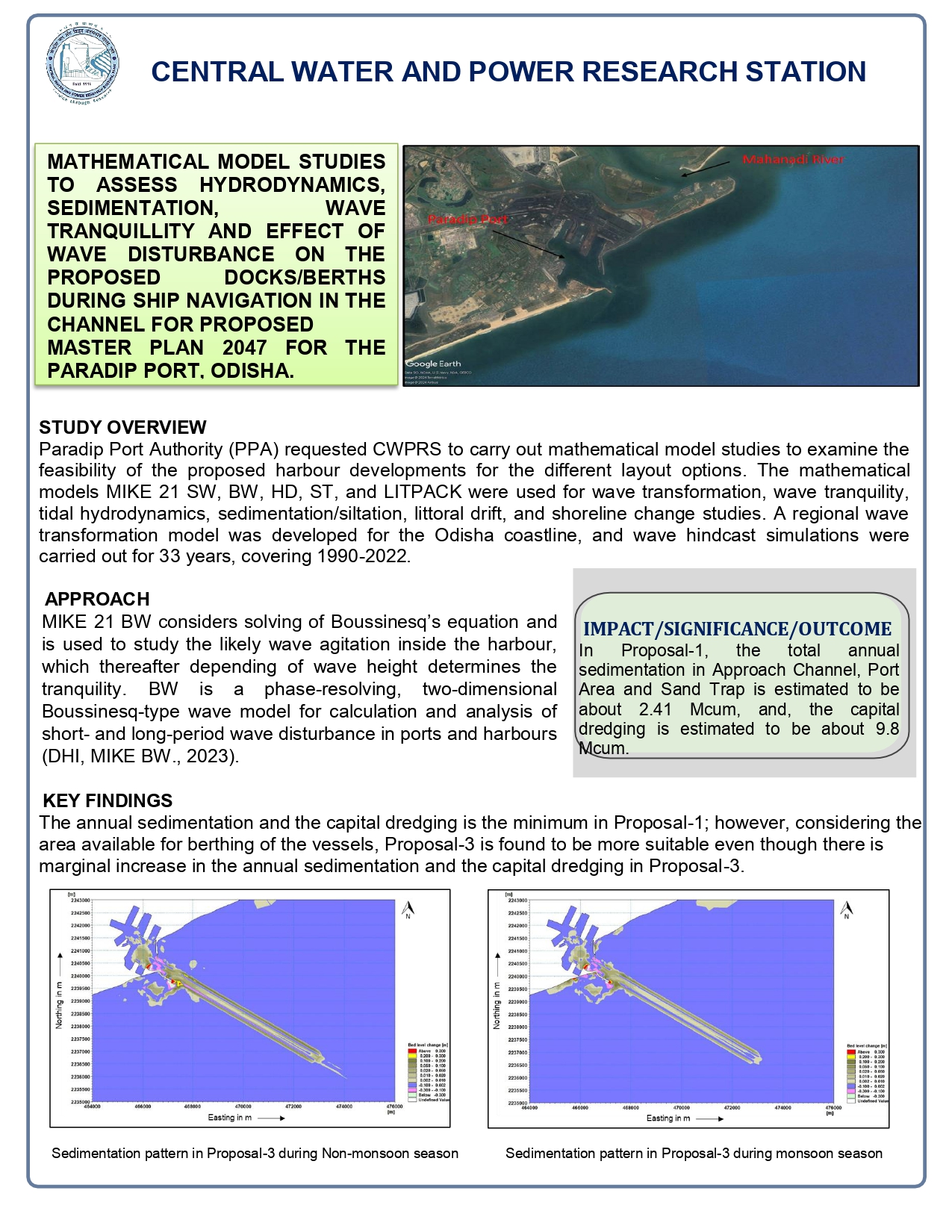
MATHEMATICAL MODEL STUDIES TO ASSESS HYDRODYNAMICS, SEDIMENTATION, WAVE TRANQUILLITY AND EFFECT OF WAVE DISTURBANCE ON THE PROPOSED DOCKS/BERTHS DURING SHIP NAVIGATION IN THE CHANNEL FOR PROPOSED MASTER PLAN 2047 FOR THE PARADIP PORT, ODISHA
Download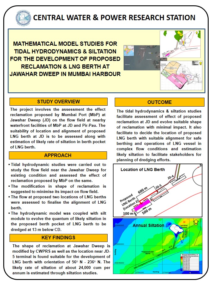
MATHEMATICAL MODEL STUDIES FOR TIDAL HYDRODYNAMICS & SILTATION FOR THE DEVELOPMENT OF PROPOSED RECLAMATION & LNG BERTH AT JAWAHAR DWEEP IN MUMBAI HARBOUR
Download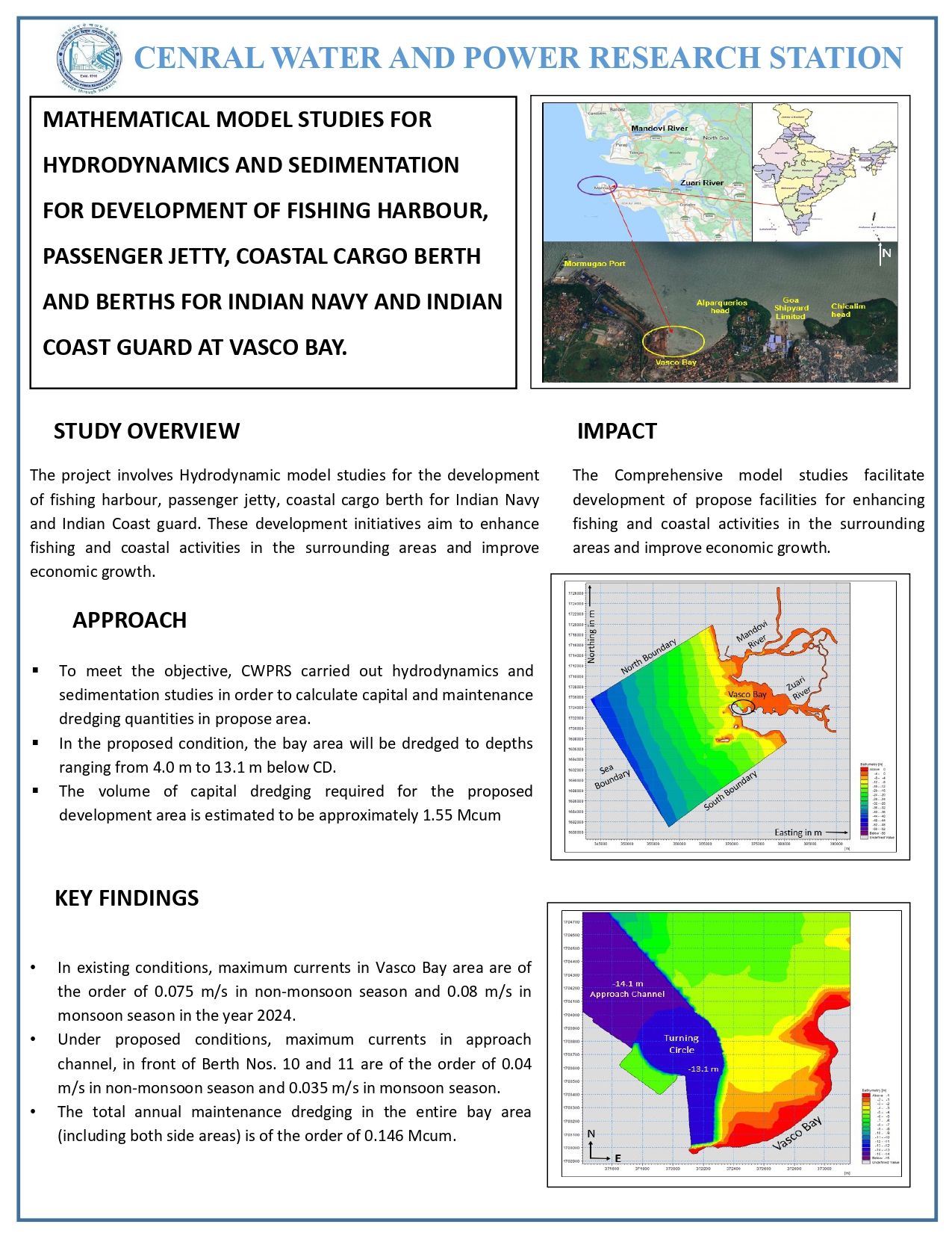
MATHEMATICAL MODEL STUDIES FOR HYDRODYNAMICS AND SEDIMENTATION FOR DEVELOPMENT OF FISHING HARBOUR, PASSENGER JETTY, COASTAL CARGO BERTH AND BERTHS FOR INDIAN NAVY AND INDIAN COAST GUARD AT VASCO BAY
Download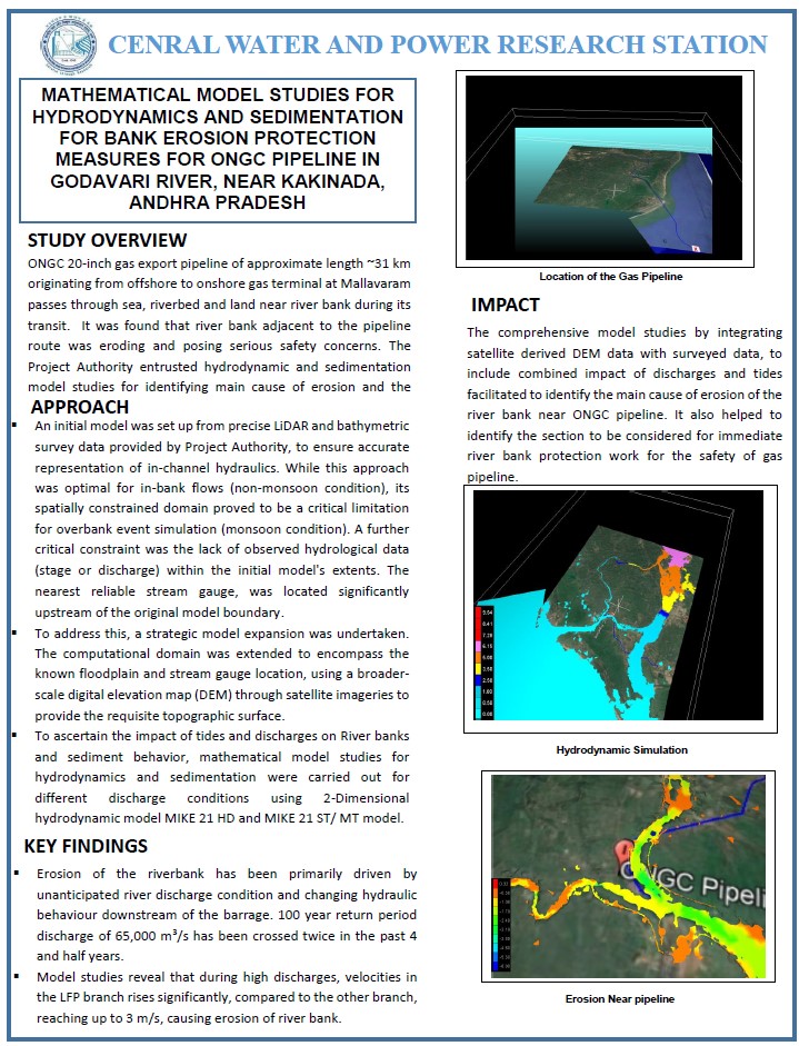
MATHEMATICAL MODEL STUDIES FOR HYDRODYNAMICS AND SEDIMENTATION FOR BANK EROSION PROTECTION MEASURES FOR ONGC PIPELINE IN GODAVARI RIVER, NEAR KAKINADA, ANDHRA PRADESH
Download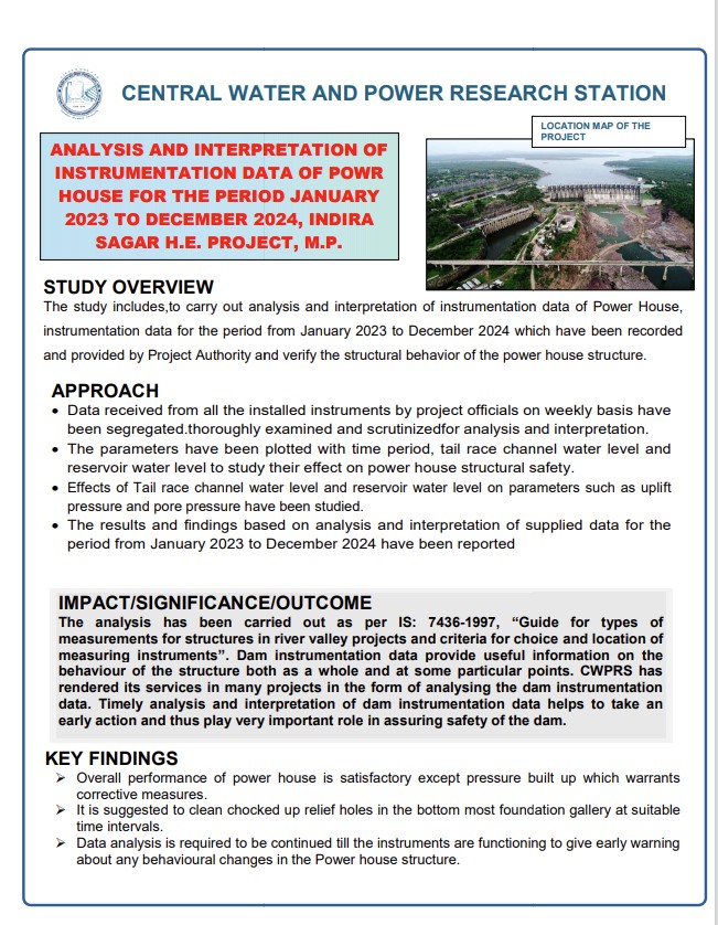
ANALYSIS AND INTERPRETATION OF INSTRUMENTATION DATA OF POWR HOUSE FOR THE PERIOD JANUARY 2023 TO DECEMBER 2024, INDIRA SAGAR H.E. PROJECT, M.P
Download
MATHEMATICAL MODEL STUDIES FOR HYDRODYNAMICS & SILTATION FOR DEVELOPMENT OF INTERNATIONAL CONTAINER TRANSSHIPMENT PORT (ICTP) AT GALATHEA BAY, A&N ISLANDS
Download
")
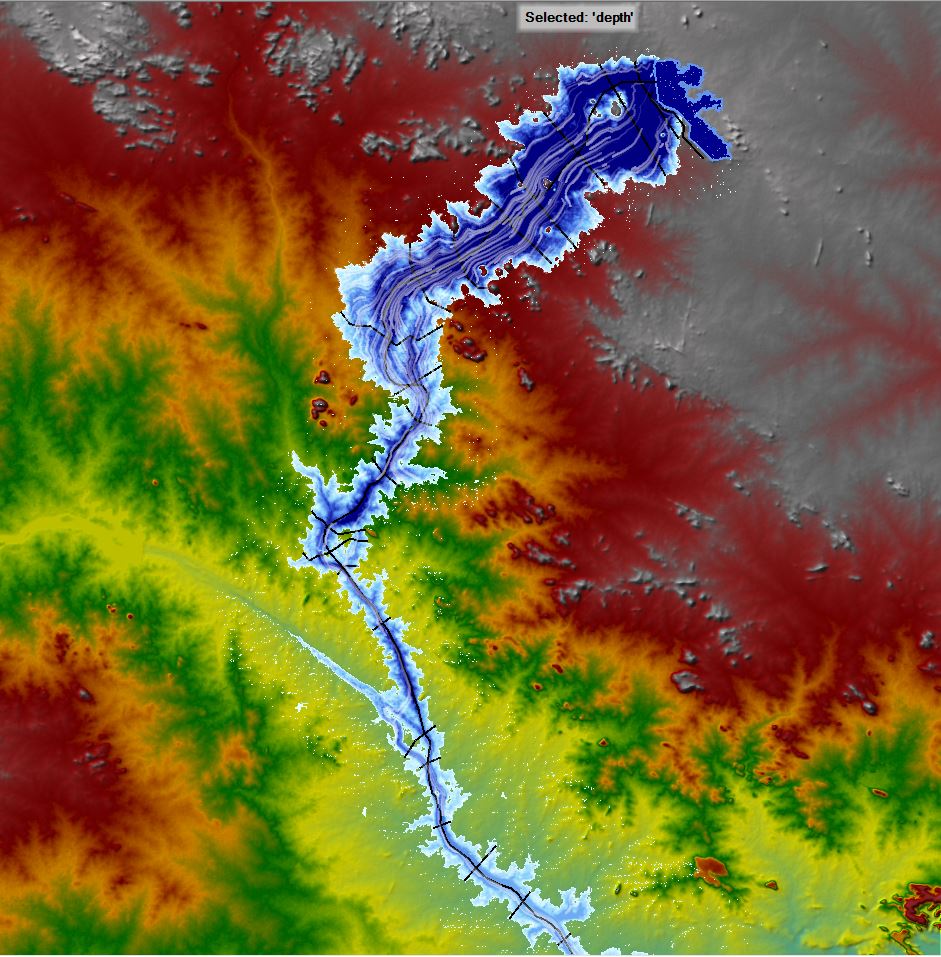
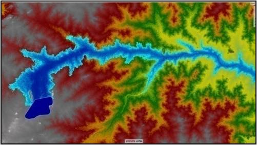
.jpg "Flood inunadation map of Kurumurthyraya reservoir")
.jpg "Flood inundation map of Venkatagiri reservoir (1)")


.JPG "Flood inundation map of Venkatagiri reservoir (3)")


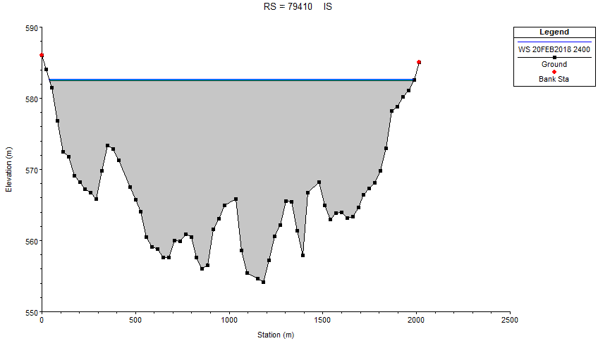
The Disaster Management Planning (DMP) is engaged in carrying out Flood Inundation studies essential for Emergency Action Planning in the event of Dam Break scenarios. The division engages in a variety of projects encompassing Dam Break Analysis, Flood Routing, Nala Diversion, and Storm Water Drainage studies. The dam break studies would help to meticulously assess diverse breach scenarios to determine flood inundation levels, velocity, and the propagation of flood waves. These findings serve as pivotal inputs for crafting Emergency Action Plans (EAPs) crucial for disaster management strategies. Aligned with the national water policy of the Government of India, there's a concerted effort to develop EAPs for major dams across the country. Consequently, various dam authorities are actively engaged in formulating EAPs under the Dam Rehabilitation and Improvement Program (DRIP), with support from international organizations such as the World Bank. The Division incorporates advanced numerical modeling techniques to carry out several research projects vital for effective disaster management planning.
Broad areas of expertise
- Dam Break Analysis and Inputs for Emergency Action Plan for reservoirs.
- Storm Water Drainage Studies.
- Review and Assessment study for diversion of Nala passing.
Significant Contributions
- Mathematical model studies on the modified layout of proposed International Airport of Navi Mumbai
- Significant storm water drainage studies for Dungi, Khalche Owale and Bhangarapada village near NMIA, Navi Mumbai and Nala diversion studies in Mahalani Nala, Jharkhand and Diversion of River Sukri, Jharkhand and Diversion of Morcha and Mokha Nala, Uttar Pradesh and Nala at Nimdih, Saraikela, Jharkhand.
- Dam Break Studies and Emergency Action Planning for Khadakwasla Irrigation System and Temghar Dam, Maharashtra.
- Dam break analysis and flood zone mapping for emergency action planning of Nathpa Dam, Himachal Pradesh, for reservoirs namely Kurumurthyraya Venkatadri reservoir, Mallana Sagar, Kondapochamma Sagar,Gandhamala, Baswapur,Shivannegudem and Kistrampally at Telangana, Tilaya dam, Jharkand, Kanhar dam, Uttar Pradesh, Ukai at Gujarat, Gandhisagar at Madhya pradesh, Vishakapatnam Steel plant dams have been carried out in this division.
The DMP division is well equipped with high performance computers for facilitating dam break analysis and EAP studies.
Softwares
- Arc-GIS
- HEC-RAS
.jpg)


.jpg)


© Copyright © 2024 - Content owned by Central Water and Power Research Station (CWPRS), Developed, hosted, and maintained by ADG Online Solutions Pvt. Ltd.